
Mapa topográfico Union Grove
Mapa interativo
Clique no mapa para exibir a altitude.
Sobre este mapa
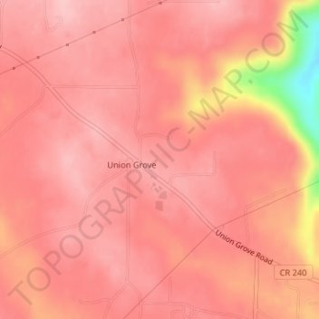
Nome: Mapa topográfico Union Grove, altitude, relevo.
Local: Union Grove, Marshall County, Alabama, United States (34.39586 -86.45835 34.40841 -86.44003)
Altitude média: 299 m
Altitude mínima: 174 m
Altitude máxima: 328 m
Union Grove is located in western Marshall County at 34°24′0″N 86°26′46″W / 34.40000°N 86.44611°W / 34.40000; -86.44611 (34.400088, -86.446049). It is 7 miles (11 km) northeast of Arab and 5 miles (8 km) southwest of Guntersville Dam on the Tennessee River. Union Grove sits at an elevation of 1,040 feet (320 m) above sea level on the relatively flat top of Brindley Mountain, near the southwest end of the Appalachian Plateau. Electricity service in Union Grove is provided through Arab Electric Cooperative, which comes through the Tennessee Valley Authority.
Outros mapas topográficos
Clique em um mapa para visualizar sua topografia, sua altitude e seu relevo.
Guntersville
United States > Alabama > Marshall County
Guntersville, Marshall County, Alabama, 35976, United States
Altitude média: 242 m
Needmore
United States > Alabama > Marshall County
Needmore, Marshall County, Alabama, United States
Altitude média: 294 m
Albertville
United States > Alabama > Marshall County
Albertville, Marshall County, Alabama, 35950, United States
Altitude média: 309 m
Bucksnort
United States > Alabama > Marshall County
Bucksnort, Marshall County, Alabama, 35747, United States
Altitude média: 289 m
Union Grove
United States > Alabama > Marshall County > Union Grove
Union Grove, Marshall County, Alabama, United States
Altitude média: 300 m
Lake Guntersville State Park
United States > Alabama > Marshall County > Guntersville
Lake Guntersville State Park, Guntersville, Marshall County, Alabama, United States
Altitude média: 242 m
Grant
United States > Alabama > Marshall County
Grant, Marshall County, Alabama, 35847, United States
Altitude média: 300 m
Shoal Creek
United States > Alabama > Marshall County > Arab
Shoal Creek, Arab, Marshall County, Alabama, 35016, United States
Altitude média: 327 m
Lindsay Lane
United States > Alabama > Marshall County > Guntersville
Lindsay Lane, Guntersville, Marshall County, Alabama, 35976, United States
Altitude média: 249 m
Boaz
United States > Alabama > Marshall County
Boaz, Marshall County, Alabama, 35957, United States
Altitude média: 320 m
Wyeth City
United States > Alabama > Marshall County > Guntersville > Wyeth City
Wyeth City, Guntersville, Marshall County, Alabama, 35976, United States
Altitude média: 230 m
Guntersville
United States > Alabama > Marshall County > Guntersville
Guntersville, Marshall County, Alabama, 35976, United States
Altitude média: 208 m
Bob Mountain
United States > Alabama > Marshall County
Bob Mountain, Marshall County, Alabama, United States
Altitude média: 206 m
Arab
United States > Alabama > Marshall County
Arab, Marshall County, Alabama, 35016, United States
Altitude média: 314 m