
Mapa topográfico Albertville
Mapa interativo
Clique no mapa para exibir a altitude.
Sobre este mapa
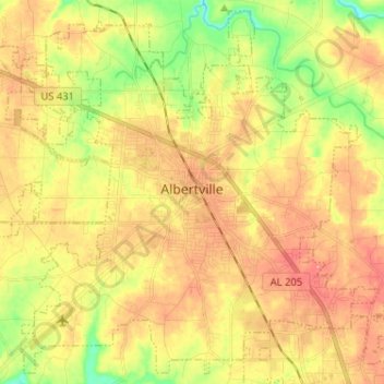
Nome: Mapa topográfico Albertville, altitude, relevo.
Local: Albertville, Marshall County, Alabama, 35950, United States (34.21637 -86.27448 34.31681 -86.14596)
Altitude média: 309 m
Altitude mínima: 254 m
Altitude máxima: 356 m
According to the U.S. Census Bureau, Albertville has a total area of 27.0 square miles (69.9 km2), of which 0.1 square miles (0.3 km2), or 0.37%, are water. The city sits at an elevation of 1,060 feet (320 m) atop Sand Mountain, a plateau that in this area is about 15 miles (24 km) wide. The Tennessee Valley Divide passes through the southern part of the city. The majority of the city drains north to Short Creek, a tributary of the Tennessee River, while the southern part drains to Slab Creek, a west-flowing tributary of the Locust Fork of the Black Warrior River. The current slogan of Albertville is "The Heart of Sand Mountain", which can be seen on the welcome sign coming into the city.
Outros mapas topográficos
Clique em um mapa para visualizar sua topografia, sua altitude e seu relevo.
Guntersville
United States > Alabama > Marshall County
Guntersville, Marshall County, Alabama, 35976, United States
Altitude média: 242 m
Needmore
United States > Alabama > Marshall County
Needmore, Marshall County, Alabama, United States
Altitude média: 294 m
Bucksnort
United States > Alabama > Marshall County
Bucksnort, Marshall County, Alabama, 35747, United States
Altitude média: 289 m
Union Grove
United States > Alabama > Marshall County > Union Grove
Union Grove, Marshall County, Alabama, United States
Altitude média: 300 m
Lake Guntersville State Park
United States > Alabama > Marshall County > Guntersville
Lake Guntersville State Park, Guntersville, Marshall County, Alabama, United States
Altitude média: 242 m
Grant
United States > Alabama > Marshall County
Grant, Marshall County, Alabama, 35847, United States
Altitude média: 300 m
Shoal Creek
United States > Alabama > Marshall County > Arab
Shoal Creek, Arab, Marshall County, Alabama, 35016, United States
Altitude média: 327 m
Lindsay Lane
United States > Alabama > Marshall County > Guntersville
Lindsay Lane, Guntersville, Marshall County, Alabama, 35976, United States
Altitude média: 249 m
Union Grove
United States > Alabama > Marshall County
Union Grove, Marshall County, Alabama, United States
Altitude média: 299 m
Boaz
United States > Alabama > Marshall County
Boaz, Marshall County, Alabama, 35957, United States
Altitude média: 320 m
Wyeth City
United States > Alabama > Marshall County > Guntersville > Wyeth City
Wyeth City, Guntersville, Marshall County, Alabama, 35976, United States
Altitude média: 230 m
Guntersville
United States > Alabama > Marshall County > Guntersville
Guntersville, Marshall County, Alabama, 35976, United States
Altitude média: 208 m
Bob Mountain
United States > Alabama > Marshall County
Bob Mountain, Marshall County, Alabama, United States
Altitude média: 206 m
Arab
United States > Alabama > Marshall County
Arab, Marshall County, Alabama, 35016, United States
Altitude média: 314 m