
Faça uma doação
Mapa topográfico Baja California Sur
Clique no mapa para exibir a altitude.
Faça uma doação
Baja California Sur
The climate of the state is dry, with an average annual temperature of 18–22 °C and average annual rainfall of less than 200mm. The lower elevations are the driest and hottest, with summer daytime temperatures above 40 °C; wintertime temperatures may fall below freezing. The exception to desert conditions is the Los Cabos region, classified as semi-moist because of Pacific hurricane activity which affects the region. In the spring, prevailing winds are from the west and in the summer from the south and southwest. In the fall, they are from the northwest and in the winter from the north and northwest.
Faça uma doação
Sobre este mapa
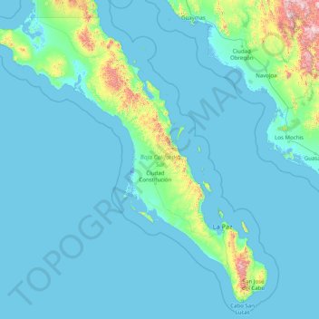
Nome: Mapa topográfico Baja California Sur, altitude, relevo.
Local: Baja California Sur, Mexico (22.87163 -115.76919 28.00000 -109.41317)
Altitude média: 90 m
Altitude mínima: -5 m
Altitude máxima: 2.265 m
Faça uma doação
Outros mapas topográficos
Clique em um mapa para visualizar sua topografia, sua altitude e seu relevo.
Ojo de Agua
Mexico > State of Mexico > Tecámac
Ojo de Agua is the largest colonia in the municipality of Tecámac in State of Mexico, Mexico. It is located in the northeastern part of the state, northeast of Mexico City and within the Greater Mexico City urban area. It had a 2010 census population of 242,272 inhabitants, or 66.45 percent of its…
Altitude média: 2.297 m
Faça uma doação
Atlixco
The city of Atlixco is in the west of the state of Puebla at an elevation of 1,881 meters above sea level, 25 km from the state capital of Puebla. The main economic activities of the city are agriculture and basic commerce. It lies at the foot of the Cerro de San Miguel mountain, which is the main geographical…
Altitude média: 1.873 m
Faça uma doação
Faça uma doação
Ciudad Constitución
Mexico > Baja California Sur > Municipio de Comondú > Ciudad Constitución
Altitude média: 54 m
Faça uma doação