
Faça uma doação
Mapa topográfico Atlixco
Clique no mapa para exibir a altitude.
Faça uma doação
Atlixco
The city of Atlixco is in the west of the state of Puebla at an elevation of 1,881 meters above sea level, 25 km from the state capital of Puebla. The main economic activities of the city are agriculture and basic commerce. It lies at the foot of the Cerro de San Miguel mountain, which is the main geographical and cultural landmark, marked by a small hermitage at the top dedicated to the Archangel Michael. According to local lore, a demon was entrapped in the well there, after causing problems in the community. There are also lookout points that provide panoramic views of the city.
Faça uma doação
Sobre este mapa
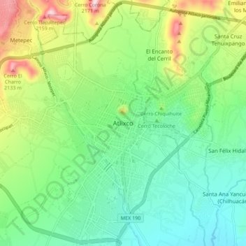
Nome: Mapa topográfico Atlixco, altitude, relevo.
Local: Atlixco, Puebla, 74260, Mexico (18.86889 -98.47778 18.94889 -98.39778)
Altitude média: 1.873 m
Altitude mínima: 1.740 m
Altitude máxima: 2.168 m
Faça uma doação