
Faça uma doação
Mapa topográfico Lichtenberg
Clique no mapa para exibir a altitude.
Faça uma doação
Sobre este mapa
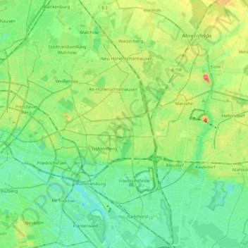
Nome: Mapa topográfico Lichtenberg, altitude, relevo.
Local: Lichtenberg, Berlin, Germany (52.46784 13.45620 52.59646 13.56770)
Altitude média: 50 m
Altitude mínima: 25 m
Altitude máxima: 104 m
Faça uma doação
Outros mapas topográficos
Clique em um mapa para visualizar sua topografia, sua altitude e seu relevo.
Teufelsberg
Teufelsberg was originally thought to be 115 metres (377 ft) high, which placed it at the same elevation as Großer Müggelberg (the summit of Müggelberge), and was the highest point in West Berlin. New measurements show that Teufelsberg is actually 120.1 metres (394 ft) high, making it higher than Großer…
Altitude média: 54 m
Viktoriapark
On the occasion of the elevation of the monument ideas appeared to lay out a park around it. Two years later the design of a park was put out to tender. Hermann Mächtig (*1837-1909*), since 1877 Berlin's city garden director, handed in a design, already using the name Victoria Park, in honour of Princess…
Altitude média: 45 m
Faça uma doação
Faça uma doação