
Faça uma doação
Mapa topográfico Flughafensee
Clique no mapa para exibir a altitude.
Faça uma doação
Sobre este mapa
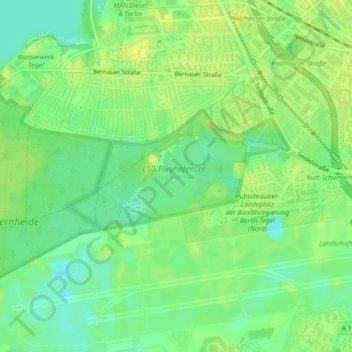
Nome: Mapa topográfico Flughafensee, altitude, relevo.
Local: Flughafensee, Tegel, Reinickendorf, Berlin, Germany (52.56483 13.28129 52.57071 13.29430)
Altitude média: 35 m
Altitude mínima: 25 m
Altitude máxima: 42 m
Faça uma doação
Outros mapas topográficos
Clique em um mapa para visualizar sua topografia, sua altitude e seu relevo.
Faça uma doação
Neukölln
Neukölln is on the North European Plain, which is typically characterized by low-lying marshy woodlands with a mainly flat topography. The quarter lies on the geological border between the shallow Weichselian Warsaw-Berlin Urstromtal glacial valley and the northernmost edge of the Teltow young drift ground…
Altitude média: 43 m
Faça uma doação
Teufelsberg
Teufelsberg was originally thought to be 115 metres (377 ft) high, which placed it at the same elevation as Großer Müggelberg (the summit of Müggelberge), and was the highest point in West Berlin. New measurements show that Teufelsberg is actually 120.1 metres (394 ft) high, making it higher than Großer…
Altitude média: 54 m
Kreuzberg
In contrast to many other areas of Berlin, which were villages before their integration into Berlin, Kreuzberg has a rather short history. It was formed on 1 October 1920 by the Greater Berlin Act, which provided for the incorporation of suburbs and the reorganisation of Berlin into twenty boroughs. The…
Altitude média: 43 m
Faça uma doação
Faça uma doação
Faça uma doação
Faça uma doação
Faça uma doação
Faça uma doação
Faça uma doação
Faça uma doação
Faça uma doação
Faça uma doação
Faça uma doação
Faça uma doação