
Mapa topográfico Nebraska
Mapa interativo
Clique no mapa para exibir a altitude.
Sobre este mapa
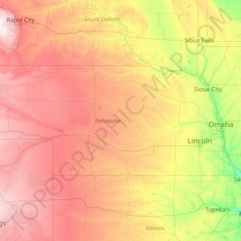
Nome: Mapa topográfico Nebraska, altitude, relevo.
Local: Nebraska, United States (39.99998 -104.05352 43.00127 -95.30805)
Altitude média: 747 m
Altitude mínima: 255 m
Altitude máxima: 2.159 m
Nebraska is composed of two major land regions: the Dissected Till Plains and the Great Plains. The easternmost portion of the state was scoured by Ice Age glaciers; the Dissected Till Plains were left after the glaciers retreated. The Dissected Till Plains is a region of gently rolling hills; Omaha and Lincoln are in this region. The Great Plains occupy most of western Nebraska, with the region consisting of several smaller, diverse land regions, including the Sandhills, the Pine Ridge, the Rainwater Basin, the High Plains and the Wildcat Hills. Panorama Point, at 5,424 feet (1,653 m), is Nebraska's highest point; though despite its name and elevation, it is a relatively low rise near the Colorado and Wyoming borders. A past tourism slogan for the state of Nebraska was "Where the West Begins" (it has since been changed to "Honestly, it's not for everyone"). Locations given for the beginning of the "West" in Nebraska include the Missouri River, the intersection of 13th and O Streets in Lincoln (where it is marked by a red brick star), the 100th meridian, and Chimney Rock.
Outros mapas topográficos
Clique em um mapa para visualizar sua topografia, sua altitude e seu relevo.
Houston
United States > Texas > Harris County
Houston, Harris County, Texas, United States
Altitude média: 25 m
The Woodlands
United States > Texas > Montgomery County
The Woodlands, Montgomery County, Texas, United States
Altitude média: 47 m
New Orleans
United States > Louisiana > Orleans Parish
New Orleans, Orleans Parish, Louisiana, United States
Altitude média: 1 m
Albuquerque
United States > New Mexico > Bernalillo County
Albuquerque, Bernalillo County, New Mexico, United States
Altitude média: 1.688 m
Jacksonville
United States > Florida > Duval County
Jacksonville, Duval County, Florida, United States
Altitude média: 10 m
Fort Worth
United States > Texas > Tarrant County
Fort Worth, Tarrant County, Texas, United States
Altitude média: 212 m
Bay Mills
United States > Michigan > Chippewa County
Bay Mills, Bay Mills Township, Chippewa County, Michigan, 49715, United States
Altitude média: 182 m
Brooklyn
United States > New York > New York
Brooklyn, Kings County, New York, United States
Altitude média: 9 m
Seattle
United States > Washington > King County
Seattle, King County, Washington, United States
Altitude média: 40 m
Georgetown
United States > Texas > Georgetown
Georgetown, Williamson County, Texas, United States
Altitude média: 219 m
Buncombe County
United States > North Carolina
Buncombe County, North Carolina, United States
Altitude média: 839 m
Sequoia National Park
United States > California > Tulare County
Sequoia National Park, Tulare County, California, United States
Altitude média: 2.515 m
Sacramento
United States > California > Sacramento County
Sacramento, Sacramento County, California, United States
Altitude média: 10 m
Palm Beach County
Palm Beach County, Florida, United States
Altitude média: 5 m
Central Valley
United States > California > San Joaquin County
Central Valley, San Joaquin County, California, 95201, United States
Altitude média: -1 m
Staten Island
United States > New York > New York
Staten Island, Richmond County, New York, United States
Altitude média: 9 m
Sarasota
United States > Florida > Sarasota County
Sarasota, Sarasota County, Florida, United States
Altitude média: 7 m
Sonoma County
Sonoma County, California, United States
Altitude média: 210 m