
Faça uma doação
Mapa topográfico Charlton
Clique no mapa para exibir a altitude.
Faça uma doação
Sobre este mapa
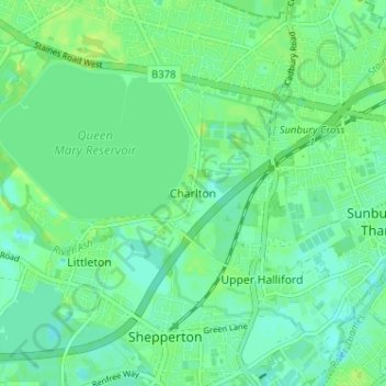
Nome: Mapa topográfico Charlton, altitude, relevo.
Altitude média: 13 m
Altitude mínima: 7 m
Altitude máxima: 20 m
Faça uma doação
Outros mapas topográficos
Clique em um mapa para visualizar sua topografia, sua altitude e seu relevo.
Queen Mary Reservoir
United Kingdom > England > Surrey > Borough of Spelthorne > Charlton
Altitude média: 14 m
Shepperton
United Kingdom > England > Surrey > Borough of Spelthorne
Shepperton has a long boundary with the River Thames in its southernmost salient, which almost surrounds Spelthorne. Old Shepperton is almost surrounded by the extreme southern meander within this. Prehistoric glacial retreat north of this has made the north bank almost flat for a considerable distance and as…
Altitude média: 12 m
Faça uma doação
Shepperton
United Kingdom > England > Surrey > Borough of Spelthorne
Shepperton has a long boundary with the River Thames in its southernmost salient, which almost surrounds Spelthorne. Old Shepperton is almost surrounded by the extreme southern meander within this. Prehistoric glacial retreat north of this has made the north bank almost flat for a considerable distance and as…
Altitude média: 12 m