
Faça uma doação
Mapa topográfico Shepperton
Clique no mapa para exibir a altitude.
Faça uma doação
Shepperton
Shepperton has a long boundary with the River Thames in its southernmost salient, which almost surrounds Spelthorne. Old Shepperton is almost surrounded by the extreme southern meander within this. Prehistoric glacial retreat north of this has made the north bank almost flat for a considerable distance and as such, elevation never exceeds 14 m above mean sea level (on the border of Laleham). The river never exceeds 11.5 m, (beside Dumsey Meadow and under Chertsey Bridge). The lowest elevation is 9 m in flood meadows at the confluence of the Ash with the Thames. The Ash is the border with Littleton and Sunbury-on-Thames (mostly, to the northeast, with its technical hamlet, Upper Halliford).
Faça uma doação
Sobre este mapa
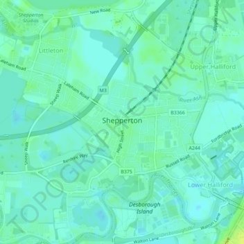
Nome: Mapa topográfico Shepperton, altitude, relevo.
Altitude média: 12 m
Altitude mínima: 7 m
Altitude máxima: 23 m
Faça uma doação
Outros mapas topográficos
Clique em um mapa para visualizar sua topografia, sua altitude e seu relevo.
Upper Halliford
United Kingdom > England > Surrey > Borough of Spelthorne
Based on 1841 census statistics, Samuel Lewis (publisher) in his 1848 A topographical guide to England stated the population of the parish of Sunbury which included Charlton and Upper Halliford, an area of 2,580 acres (1,040 ha) was 1,828.
Altitude média: 13 m
Faça uma doação
Queen Mary Reservoir
United Kingdom > England > Surrey > Borough of Spelthorne > Charlton
Altitude média: 14 m
Staines-upon-Thames
United Kingdom > England > Surrey > Borough of Spelthorne
Much of the town is built on gravel "islands" that rise above the low-lying floodplains of the Thames and Colne. These gravel deposits have a typical maximum elevation of 14 m (46 ft) above ordnance datum (AOD) and are as little as 0.5 m (1.6 ft) above the surrounding floodplain. Staines High Street, oriented…
Altitude média: 20 m
Faça uma doação