
Faça uma doação
Mapa topográfico Catubig
Clique no mapa para exibir a altitude.
Faça uma doação
Catubig
Another tale was mentioned that the name Catubig was also a product of a 'word compact' between Americans and Filipinos. It was stated that an American surveyors saw a cat sunbathing by rolling along the grassy edge of the brook. They then approached a young lady who was doing her laundry and asked, “What is that, cat?” The lass, hardly seeing the cat which was in higher elevation, and not knowing what the foreigners were asking about simply responded, “Tubig,” meaning the water of the brook.
Faça uma doação
Sobre este mapa
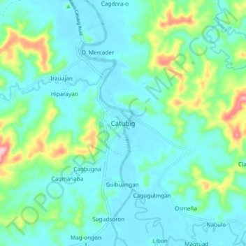
Nome: Mapa topográfico Catubig, altitude, relevo.
Local: Catubig, Northern Samar, Eastern Visayas, Philippines (12.36787 125.01444 12.44787 125.09444)
Altitude média: 41 m
Altitude mínima: 0 m
Altitude máxima: 201 m
Faça uma doação
Outros mapas topográficos
Clique em um mapa para visualizar sua topografia, sua altitude e seu relevo.
Faça uma doação
Faça uma doação
Faça uma doação