
Faça uma doação
Mapa topográfico Catarman
Clique no mapa para exibir a altitude.
Faça uma doação
Sobre este mapa
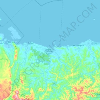
Nome: Mapa topográfico Catarman, altitude, relevo.
Local: Catarman, Northern Samar, Eastern Visayas, 6400, Philippines (12.30426 124.49381 12.68519 124.73548)
Altitude média: 51 m
Altitude mínima: -3 m
Altitude máxima: 456 m
Faça uma doação
Outros mapas topográficos
Clique em um mapa para visualizar sua topografia, sua altitude e seu relevo.
Catubig
Another tale was mentioned that the name Catubig was also a product of a 'word compact' between Americans and Filipinos. It was stated that an American surveyors saw a cat sunbathing by rolling along the grassy edge of the brook. They then approached a young lady who was doing her laundry and asked, “What is…
Altitude média: 41 m
Faça uma doação
Faça uma doação
Faça uma doação
Faça uma doação
Faça uma doação
Faça uma doação
Faça uma doação
San Jose
The municipality is in a valley bounded on the east by the Palusong Mountain Range moving south and on the west by the Hitaasan Mountain Range. The land is generally alluvial flat and swamplands which has an elevation of less than 10 metres (33 ft) above sea level, while going south, south easterly, the…
Altitude média: 15 m
Faça uma doação
Faça uma doação
Faça uma doação