
Mapa topográfico Belluno
Clique no mapa para exibir a altitude.
Belluno
The national park includes mountain ranges of Alpi Feltrine (Vette di Feltre, Cimonega, Pizzocco, Brendol, Agnelezze), Monti del Sole, Schiara, Talvena, Prampèr, and Spiz di Mezzodì. There are high-altitude areas, karst rocks, and debris slopes, ideal habitat for high-mountain species.
Sobre este mapa
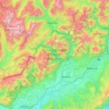
Nome: Mapa topográfico Belluno, altitude, relevo.
Local: Belluno, Veneto, Italy, Parco Nazionale Dolomiti Bellunesi (46.04338 11.76610 46.31945 12.26498)
Altitude média: 1.121 m
Altitude mínima: 158 m
Altitude máxima: 3.181 m
Outros mapas topográficos
Clique em um mapa para visualizar sua topografia, sua altitude e seu relevo.
Gruppo del Pomagagnon
Italy > Veneto > Belluno > Cortina d'Ampezzo
Pomagagnon is a mountain of the Dolomites in Belluno, northern Italy. It has an elevation of 2,450 metres (8,038 ft) and is the southernmost mountain of the Cristallo Group, towering 1,200 metres (3,937 ft) over the resort of Cortina d'Ampezzo. The mountain is part of the "Natural Park of the Ampezzo…
Altitude média: 1.758 m