
Mapa topográfico Gruppo del Pomagagnon
Mapa interativo
Clique no mapa para exibir a altitude.
Gruppo del Pomagagnon
Pomagagnon is a mountain of the Dolomites in Belluno, northern Italy. It has an elevation of 2,450 metres (8,038 ft) and is the southernmost mountain of the Cristallo Group, towering 1,200 metres (3,937 ft) over the resort of Cortina d'Ampezzo. The mountain is part of the "Natural Park of the Ampezzo Dolomites".
Sobre este mapa
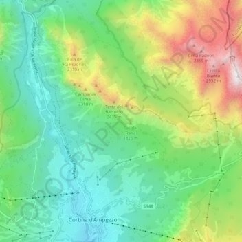
Nome: Mapa topográfico Gruppo del Pomagagnon, altitude, relevo.
Altitude média: 1.758 m
Altitude mínima: 1.159 m
Altitude máxima: 3.085 m
Outros mapas topográficos
Clique em um mapa para visualizar sua topografia, sua altitude e seu relevo.