
Obrigado por apoiar este site ❤️
Faça uma doação
Faça uma doação
Mapa topográfico Skipton
Clique no mapa para exibir a altitude.
Obrigado por apoiar este site ❤️
Faça uma doação
Faça uma doação
Sobre este mapa
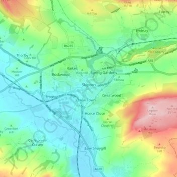
Nome: Mapa topográfico Skipton, altitude, relevo.
Local: Skipton, North Yorkshire, England, United Kingdom (53.93958 -2.04957 53.98142 -1.94936)
Altitude média: 173 m
Altitude mínima: 89 m
Altitude máxima: 367 m
Obrigado por apoiar este site ❤️
Faça uma doação
Faça uma doação
Outros mapas topográficos
Clique em um mapa para visualizar sua topografia, sua altitude e seu relevo.
Obrigado por apoiar este site ❤️
Faça uma doação
Faça uma doação
Harrogate
United Kingdom > England > North Yorkshire
Harrogate is situated on the edge of the Yorkshire Dales, with the Vale of York to the east and the upland Yorkshire Dales to the west and north-west. It has a dry and mild climate, typical of places in the rain shadow of the Pennines. It is on the A59 from Skipton to York. At an altitude of between 100 and…
Altitude média: 106 m
Obrigado por apoiar este site ❤️
Faça uma doação
Faça uma doação