
Obrigado por apoiar este site ❤️
Faça uma doação
Faça uma doação
Mapa topográfico Water Houses
Clique no mapa para exibir a altitude.
Obrigado por apoiar este site ❤️
Faça uma doação
Faça uma doação
Sobre este mapa
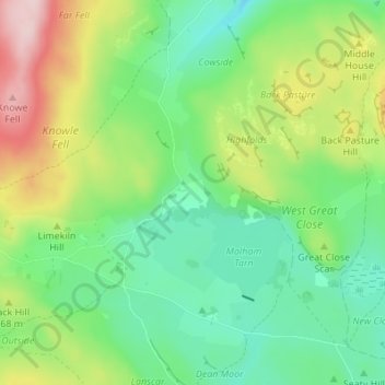
Nome: Mapa topográfico Water Houses, altitude, relevo.
Altitude média: 431 m
Altitude mínima: 339 m
Altitude máxima: 610 m
Obrigado por apoiar este site ❤️
Faça uma doação
Faça uma doação
Outros mapas topográficos
Clique em um mapa para visualizar sua topografia, sua altitude e seu relevo.
Obrigado por apoiar este site ❤️
Faça uma doação
Faça uma doação
Scarborough
United Kingdom > England > North Yorkshire
The climate is temperate with mild summers and cool, windy, winters. The hottest months of the year are July and August, with temperatures reaching an average high of 17 °C and falling to 11 °C at night. The average daytime temperatures in January are 4 °C, falling to 1 °C at night. The station's elevation…
Altitude média: 50 m
Obrigado por apoiar este site ❤️
Faça uma doação
Faça uma doação
Barton-le-Street
United Kingdom > England > North Yorkshire > Ryedale > Barton-le-Street
Altitude média: 43 m
Obrigado por apoiar este site ❤️
Faça uma doação
Faça uma doação