
Faça uma doação
Mapa topográfico Amarillo
Clique no mapa para exibir a altitude.
Faça uma doação
Amarillo
Amarillo features a unique topography characterized by its high elevation and flat plains. The city averages around 3,600 feet (1,097 meters) above sea level, making it one of the highest major cities in Texas. The surrounding landscape consists of the Llano Estacado, a vast tabletop plateau that slopes gently towards the east. This area is predominantly flat, interspersed with occasional buttes and canyons, particularly in the nearby Palo Duro Canyon, which is notable for its dramatic escarpments. The terrain is largely composed of shortgrass prairie, with arid climate conditions that result in limited vegetation and a predominantly dry ecosystem, indicative of the Chihuahuan Desert region. Overall, Amarillo's topography is defined by its expansive, flat plains and elevated landscape, contributing to its distinct character within Texas.
Faça uma doação
Sobre este mapa
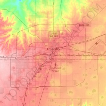
Nome: Mapa topográfico Amarillo, altitude, relevo.
Local: Amarillo, Potter County, Texas, United States (35.09449 -101.96357 35.29448 -101.65368)
Altitude média: 1.098 m
Altitude mínima: 1.001 m
Altitude máxima: 1.158 m
Faça uma doação
Outros mapas topográficos
Clique em um mapa para visualizar sua topografia, sua altitude e seu relevo.
Bushland
United States > Texas > Potter County
Bushland is located at 35°11′31″N 102°03′53″W / 35.19194°N 102.06472°W / 35.19194; -102.06472 (35.1919978, -102.0646392), at an elevation of 3,825 feet. The community is situated along Interstate 40, approximately 14 miles west of Amarillo in southwestern Potter County.
Altitude média: 1.167 m
Amarillo
United States > Texas > Potter County
Extreme temperatures range from −16 °F (−26.7 °C) on February 12, 1899 to 111 °F (43.9 °C) on June 26, 2011, but lows do not typically dip to 0 °F or −17.8 °C in most years, while highs above 100 °F or 37.8 °C are seen on 4.7 days on average. On average, there are 5.9 days of lows at or below 10…
Altitude média: 1.097 m