
Faça uma doação
Mapa topográfico Amarillo
Clique no mapa para exibir a altitude.
Faça uma doação
Amarillo
Extreme temperatures range from −16 °F (−26.7 °C) on February 12, 1899 to 111 °F (43.9 °C) on June 26, 2011, but lows do not typically dip to 0 °F or −17.8 °C in most years, while highs above 100 °F or 37.8 °C are seen on 4.7 days on average. On average, there are 5.9 days of lows at or below 10 °F or −12.2 °C, 8.8 days where the temperature fails to rise above freezing, and 61 days of 90 °F (32.2 °C)+ highs. Unlike in the Rio Grande Valley or eastern portions of Texas, days where the low does not fall below 70 °F or 21.1 °C are relatively rare, due to the aridity and elevation. Blizzards occur occasionally, but snowfall is typically light, averaging nearly 18 inches or 46 centimetres seasonally and the median figure is near 10 inches or 25 centimetres. Amarillo is also recorded as the windiest city in the U.S. by the Weather Channel.
Faça uma doação
Sobre este mapa
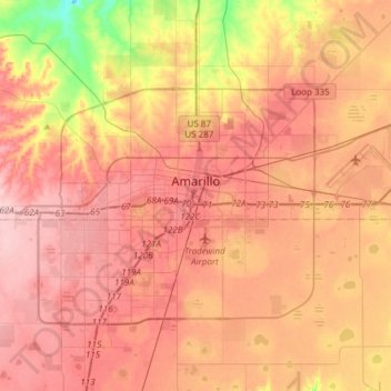
Nome: Mapa topográfico Amarillo, altitude, relevo.
Local: Amarillo, Potter County, Texas, United States (35.10200 -101.95624 35.29448 -101.65378)
Altitude média: 1.097 m
Altitude mínima: 999 m
Altitude máxima: 1.154 m
Faça uma doação
Outros mapas topográficos
Clique em um mapa para visualizar sua topografia, sua altitude e seu relevo.
Amarillo
United States > Texas > Potter County
Amarillo features a unique topography characterized by its high elevation and flat plains. The city averages around 3,600 feet (1,097 meters) above sea level, making it one of the highest major cities in Texas. The surrounding landscape consists of the Llano Estacado, a vast tabletop plateau that slopes…
Altitude média: 1.098 m
Amarillo
United States > Texas > Potter County
Extreme temperatures range from −16 °F (−26.7 °C) on February 12, 1899 to 111 °F (43.9 °C) on June 26, 2011, but lows do not typically dip to 0 °F or −17.8 °C in most years, while highs above 100 °F or 37.8 °C are seen on 4.7 days on average. On average, there are 5.9 days of lows at or below 10…
Altitude média: 1.098 m
Bushland
United States > Texas > Potter County
Bushland is located at 35°11′31″N 102°03′53″W / 35.19194°N 102.06472°W / 35.19194; -102.06472 (35.1919978, -102.0646392), at an elevation of 3,825 feet. The community is situated along Interstate 40, approximately 14 miles west of Amarillo in southwestern Potter County.
Altitude média: 1.167 m
Faça uma doação
Amarillo
United States > Texas > Potter County
Extreme temperatures range from −16 °F (−26.7 °C) on February 12, 1899 to 111 °F (43.9 °C) on June 26, 2011, but lows do not typically dip to 0 °F or −17.8 °C in most years, while highs above 100 °F or 37.8 °C are seen on 4.7 days on average. On average, there are 5.9 days of lows at or below 10…
Altitude média: 1.098 m