
Mapa topográfico Great Neva
Mapa interativo
Clique no mapa para exibir a altitude.
Great Neva
The Neva flows out of Lake Ladoga near Shlisselburg, flows through Neva's lowlands and discharges into the Baltic Sea in the Gulf of Finland. It has a length of 74 kilometres (46 mi), and the shortest distance from the source to the mouth is 45 kilometres (28 mi). The river banks are low and steep, on average about 3 to 6 metres (10 to 20 ft) and 2 to 3 metres (7 to 10 ft) at the mouth. There are three sharp turns: the Ivanovskye rapids, at Nevsky Forest Park of the Ust-Slavyanka region (the so-called "Crooked Knee"), and near the Smolny Institute, below the mouth of the river Okhta. The river declines 4.27 metres (14.0 ft) in elevation between source and mouth. At one point the river crosses a moraine ridge and forms the Ivanovskye rapids. There, at the beginning of the rapids, is the narrowest part of the river: 210 metres (690 ft). The average flow rate in the rapids is about 0.8–1.1 metres per second (2.6–3.6 ft/s). The average width along the river is 400 to 600 metres (1,300 to 2,000 ft). The widest places, at 1,000 to 1,250 metres (3,280 to 4,100 ft), are in the delta, near the gates of the marine trading port, at the end of the Ivanovskye rapids near the confluence of the river Tosna, and near the island Fabrinchny near the source. The average depth is 8 to 11 metres (26 to 36 ft); the maximum of 24 metres (79 ft) is reached above the Liteyny Bridge, and the minimum of 4.0 to 4.5 metres (13 to 15 ft) is in Ivanovskye rapids.
Sobre este mapa
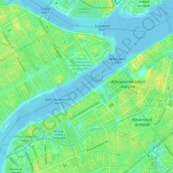
Nome: Mapa topográfico Great Neva, altitude, relevo.
Altitude média: 8 m
Altitude mínima: -2 m
Altitude máxima: 20 m
Outros mapas topográficos
Clique em um mapa para visualizar sua topografia, sua altitude e seu relevo.
Saint Petersburg
Russia > Saint Petersburg > Saint Petersburg
The elevation of Saint Petersburg ranges from the sea level to its highest point of 175.9 m (577 ft) at the Orekhovaya Hill in the Duderhof Heights in the south. Part of the city's territory west of Liteyny Prospekt is no higher than 4 m (13 ft) above sea level, and has suffered from numerous floods. Floods in…
Altitude média: 14 m