
Mapa topográfico Saint Petersburg
Mapa interativo
Clique no mapa para exibir a altitude.
Sobre este mapa
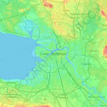
Nome: Mapa topográfico Saint Petersburg, altitude, relevo.
Altitude média: 14 m
Altitude mínima: -3 m
Altitude máxima: 73 m
The elevation of Saint Petersburg ranges from the sea level to its highest point of 175.9 m (577 ft) at the Orekhovaya Hill in the Duderhof Heights in the south. Part of the city's territory west of Liteyny Prospekt is no higher than 4 m (13 ft) above sea level, and has suffered from numerous floods. Floods in Saint Petersburg are triggered by a long wave in the Baltic Sea, caused by meteorological conditions, winds and shallowness of the Neva Bay. The five most disastrous floods occurred in 1824 (4.21 m or 13 ft 10 in above sea level, during which over 300 buildings were destroyed); 1924 (3.8 m, 12 ft 6 in); 1777 (3.21 m, 10 ft 6 in); 1955 (2.93 m, 9 ft 7 in); and 1975 (2.81 m, 9 ft 3 in). To prevent floods, the Saint Petersburg Dam has been constructed.
Outros mapas topográficos
Clique em um mapa para visualizar sua topografia, sua altitude e seu relevo.
Great Neva
Russia > Saint Petersburg > Saint Petersburg
Great Neva, Адмиралтейский округ, Saint Petersburg, Northwestern Federal District, Russia
Altitude média: 8 m
Great Neva
Russia > Saint Petersburg > Saint Petersburg
Great Neva, Palace District, Saint Petersburg, Northwestern Federal District, 190107, Russia
Altitude média: 8 m