
Faça uma doação
Mapa topográfico East Bakersfield
Clique no mapa para exibir a altitude.
Faça uma doação
Sobre este mapa
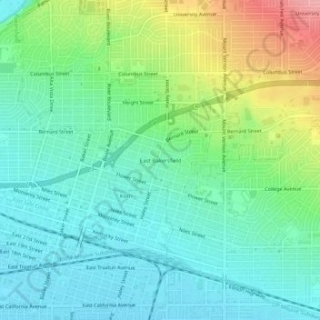
Nome: Mapa topográfico East Bakersfield, altitude, relevo.
Altitude média: 158 m
Altitude mínima: 123 m
Altitude máxima: 244 m
Faça uma doação
Outros mapas topográficos
Clique em um mapa para visualizar sua topografia, sua altitude e seu relevo.
Oildale
United States > California > Kern County
Oildale is a census-designated place (CDP) in Kern County, California, United States. Oildale is located 3.5 miles (5.6 km) north-northwest of downtown Bakersfield, at an elevation of 469 feet (143 m). The population was 32,684 at the 2010 census, up from 27,885 at the 2000 census. It is an unincorporated…
Altitude média: 164 m
Ford City
United States > California > Kern County > Taft
Ford City is a census-designated place (CDP) in Kern County, California, United States. Ford City is located 1 mile (1.61 km) north of Taft, at an elevation of 892 feet (272 m). The population was 4,348 at the 2020 census, up from 4,278 at the 2010 census. It is immediately north of Taft, between the huge…
Altitude média: 264 m
South Taft
United States > California > Kern County > Taft > South Taft
South Taft is a census-designated place (CDP) in Kern County, California, United States. South Taft is located 0.5 miles (0.8 km) south of Taft, at an elevation of 1,017 feet (310 m). The population was 2,169 at the 2010 census, up from 1,898 at the time of the 2000 census.
Altitude média: 343 m
Faça uma doação
Fellows
United States > California > Kern County
Fellows is a census-designated place (CDP) in Kern County, California, United States. Fellows is located 5 miles (8 km) west-northwest of Taft, at an elevation of 1,316 feet (401 m). The population was 106 at the 2010 census, down from 153 at the 2000 census. Fellows is surrounded on all sides by the enormous…
Altitude média: 420 m
Weedpatch
United States > California > Kern County
The community, which lies at an elevation of 387 feet (118 m), is situated off State Route 184 (Weedpatch Highway) southeast of Bakersfield, south of Lamont and about 5 miles (8 km) south of State Route 58. It is at 35°14′17″N 118°54′54″W / 35.23806°N 118.91500°W / 35.23806; -118.91500.…
Altitude média: 117 m
Inyokern
United States > California > Kern County
Inyokern (formerly Siding 16 and Magnolia) is a census-designated place (CDP) in Kern County, California, United States. Its name derives from its location near the border between Inyo and Kern Counties. Inyokern is located 8 miles (13 km) west of Ridgecrest, at an elevation of 2,434 feet (742 m). It is on the…
Altitude média: 753 m
Faça uma doação
Kernville
United States > California > Kern County > Kernville
Kernville is a census-designated place (CDP) in the southern Sierra Nevada, in Kern County, California, United States. Kernville is located 42 miles (68 km) northeast of Bakersfield, at an elevation of 2,667 feet (813 m). The population was 1,549 at the 2020 United States census, up from 1,395 at the 2010…
Altitude média: 1.135 m
Wofford Heights
United States > California > Kern County
Wofford Heights is a census-designated place (CDP) in the southern Sierra Nevada, in Kern County, California, United States. Wofford Heights is located in the west Kern River Valley, 3.5 miles (5.6 km) south-southwest of Kernville, at an elevation of 2,684 feet (818 m). The population was 2,200 at the 2010…
Altitude média: 1.114 m
Lost Hills
United States > California > Kern County
Lost Hills (formerly, Lost Hill) is a census-designated place (CDP) in Kern County, California, United States. Lost Hills is located 42 miles (68 km) west-northwest of Bakersfield, at an elevation of 305 feet (93 m). The population was 2,412 at the 2010 census, up from 1,938 at the 2000 census. About 75% of…
Altitude média: 82 m
Faça uma doação
Buttonwillow
United States > California > Kern County
Buttonwillow is an unincorporated community and census-designated place in the San Joaquin Valley, in Kern County, California. Buttonwillow is 26 miles (42 km) west of Bakersfield, at an elevation of 269 feet (82 m)). The population was 1,508 at the 2010 census, up from 1,266 at the 2000 census. The center of…
Altitude média: 87 m
Weldon
United States > California > Kern County
Weldon is a census-designated place (CDP) in Kern County, California, United States. It sits at the southeast tip of Lake Isabella. Weldon is located 9 miles (14 km) east-southeast of Wofford Heights, at an elevation of 2,654 feet (809 m). The population was 2,642 at the 2010 census, up from 2,387 at the 2000…
Altitude média: 1.030 m
Faça uma doação
Wasco
United States > California > Kern County
Wasco (formerly, Dewey and Deweyville) is a city in the San Joaquin Valley, in Kern County, California, United States. Wasco is located 24 miles (39 km) northwest of Bakersfield, at an elevation of 328 feet (100 m). The population was 25,545 at the 2010 census, up from 21,263 at the 2000 census.
Altitude média: 101 m
Maricopa
United States > California > Kern County
Maricopa is a city in Kern County, California. Maricopa is located 6.5 miles (10 km) south-southeast of Taft, at an elevation of 883 feet (269 m). The population was 1,154 at the 2010 census, up from 1,111 at the 2000 census. The Carrizo Plain is located to the northwest, and the enormous Midway-Sunset Oil…
Altitude média: 278 m
Faça uma doação
Taft Heights
United States > California > Kern County > Taft > Taft Heights
Taft Heights (formerly, Boust City) is a census-designated place (CDP) in Kern County, California, United States. Taft Heights is located 1 mile (1.6 km) west-southwest of Taft, at an elevation of 1,178 feet (359 m). The population was 1,949 at the 2010 census, up from 1,865 at the 2000 census.
Altitude média: 368 m