
Obrigado por apoiar este site ❤️
Faça uma doação
Faça uma doação
Mapa topográfico South Taft
Clique no mapa para exibir a altitude.
Obrigado por apoiar este site ❤️
Faça uma doação
Faça uma doação
South Taft
South Taft is a census-designated place (CDP) in Kern County, California, United States. South Taft is located 0.5 miles (0.8 km) south of Taft, at an elevation of 1,017 feet (310 m). The population was 2,169 at the 2010 census, up from 1,898 at the time of the 2000 census.
Obrigado por apoiar este site ❤️
Faça uma doação
Faça uma doação
Sobre este mapa
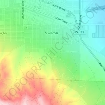
Nome: Mapa topográfico South Taft, altitude, relevo.
Local: South Taft, Taft, Kern County, California, United States (35.12245 -119.47272 35.13691 -119.44730)
Altitude média: 343 m
Altitude mínima: 249 m
Altitude máxima: 502 m
Obrigado por apoiar este site ❤️
Faça uma doação
Faça uma doação