
Mapa topográfico Nemschenreuth
Mapa interativo
Clique no mapa para exibir a altitude.
Sobre este mapa
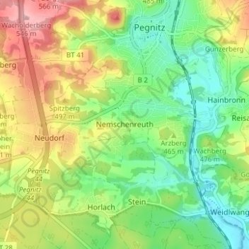
Nome: Mapa topográfico Nemschenreuth, altitude, relevo.
Altitude média: 461 m
Altitude mínima: 403 m
Altitude máxima: 546 m
Outros mapas topográficos
Clique em um mapa para visualizar sua topografia, sua altitude e seu relevo.
Hainbronn
Deutschland > Bayern > Landkreis Bayreuth > Pegnitz
Hainbronn, Pegnitz, Landkreis Bayreuth, Bayern, 91257, Deutschland
Altitude média: 467 m
Reisach
Deutschland > Bayern > Landkreis Bayreuth > Pegnitz
Reisach, Pegnitz, Landkreis Bayreuth, Bayern, 91257, Deutschland
Altitude média: 466 m
Trockau
Deutschland > Bayern > Landkreis Bayreuth > Pegnitz > Trockau
Trockau, Pegnitz, Landkreis Bayreuth, Bayern, Deutschland
Altitude média: 501 m