
Mapa topográfico Hainbronn
Mapa interativo
Clique no mapa para exibir a altitude.
Sobre este mapa
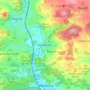
Nome: Mapa topográfico Hainbronn, altitude, relevo.
Altitude média: 467 m
Altitude mínima: 403 m
Altitude máxima: 564 m
Birklmühle | Bodendorf | Bronn | Buchau | Büchenbach | Großkrausmühle | Haidmühle | Hainbronn | Hammerbühl | Hedelmühle | Heroldsreuth | Herrenmühle | Hollenberg | Horlach | Hufeisen-Waldhaus | Kaltenthal | Kleinkrausmühle | Körbeldorf | Kosbrunn | Kotzenhammer | Langenreuth | Lehm | Leups | Leupsermühle | Lobensteig | Lüglas | Nemschenreuth | Neudorf | Neuhof | Oberhauenstein | Pegnitz (Kernbereich) | Penzenreuth | Pertenhof | Reisach | Rosenhof | Scharthammer | Stein | Stemmenreuth | Trockau | Troschenreuth | Unterhauenstein | Vestenmühle | Weidelwangermühle | Weidmannshöhe | Willenberg | Willenreuth | Wolfslohe | Ziegelhütte | Zips
Outros mapas topográficos
Clique em um mapa para visualizar sua topografia, sua altitude e seu relevo.
Nemschenreuth
Deutschland > Bayern > Landkreis Bayreuth > Pegnitz
Nemschenreuth, Pegnitz, Landkreis Bayreuth, Bayern, 91257, Deutschland
Altitude média: 461 m
Reisach
Deutschland > Bayern > Landkreis Bayreuth > Pegnitz
Reisach, Pegnitz, Landkreis Bayreuth, Bayern, 91257, Deutschland
Altitude média: 466 m
Trockau
Deutschland > Bayern > Landkreis Bayreuth > Pegnitz > Trockau
Trockau, Pegnitz, Landkreis Bayreuth, Bayern, Deutschland
Altitude média: 501 m