
Mapa topográfico Little Amwell
Clique no mapa para exibir a altitude.
Sobre este mapa
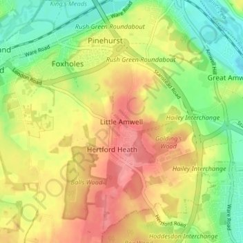
Nome: Mapa topográfico Little Amwell, altitude, relevo.
Altitude média: 65 m
Altitude mínima: 27 m
Altitude máxima: 102 m
Outros mapas topográficos
Clique em um mapa para visualizar sua topografia, sua altitude e seu relevo.
Astonbury Wood
United Kingdom > England > Hertfordshire > East Hertfordshire > Aston
Altitude média: 83 m
Sawbridgeworth
United Kingdom > England > Hertfordshire > East Hertfordshire > Sawbridgeworth
Altitude média: 67 m
Bishop's Stortford
United Kingdom > England > Hertfordshire > East Hertfordshire > Thorley
Stortford, along with the rest of Britain, has a temperate maritime climate, with cool summers and mild winters. The nearest weather station for which averages and extremes are available is Stansted Airport, about 2+1⁄2 miles (4 kilometres) due east of Stortford's town centre. Located at an elevation of over…
Altitude média: 83 m
King's Meads
United Kingdom > England > Hertfordshire > East Hertfordshire > Ware
Altitude média: 53 m
Furneux Pelham
United Kingdom > England > Hertfordshire > East Hertfordshire > Furneux Pelham
Altitude média: 113 m
Thundridge
United Kingdom > England > Hertfordshire > East Hertfordshire > High Cross
Altitude média: 78 m
Stocking Pelham
United Kingdom > England > Hertfordshire > East Hertfordshire > Stocking Pelham
Altitude média: 114 m
Datchworth
United Kingdom > England > Hertfordshire > East Hertfordshire > Datchworth
Altitude média: 102 m
Buntingford
United Kingdom > England > Hertfordshire > East Hertfordshire > Buntingford
Altitude média: 110 m
Hertford Heath Nature Reserve
United Kingdom > England > Hertfordshire > East Hertfordshire > Hertford Heath
Altitude média: 79 m
Buntingford
United Kingdom > England > Hertfordshire > East Hertfordshire > Buntingford
Altitude média: 110 m
Hertford Lock No 1
United Kingdom > England > Hertfordshire > East Hertfordshire > Hertford
Altitude média: 53 m
Braughing
United Kingdom > England > Hertfordshire > East Hertfordshire > Braughing
Altitude média: 104 m
Sawbridgeworth
United Kingdom > England > Hertfordshire > East Hertfordshire > Sawbridgeworth
Altitude média: 67 m