Geolocalizar

Mapa topográfico Aston

Mapa interativo

Clique no mapa para exibir a altitude.

Sobre este mapa

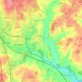
Nome: Mapa topográfico Aston, altitude, relevo.

Local: Aston, East Hertfordshire, Hertfordshire, England, United Kingdom (51.85320 -0.16118 51.91547 -0.12087)

Altitude média: 99 m

Altitude mínima: 52 m

Altitude máxima: 143 m

Outros mapas topográficos

Clique em um mapa para visualizar sua topografia, sua altitude e seu relevo.

Astonbury Wood

United Kingdom > England > Hertfordshire > East Hertfordshire > Aston

Astonbury Wood, Aston, East Hertfordshire, Hertfordshire, England, United Kingdom

Altitude média: 83 m

Stanstead St Margarets

United Kingdom > England > Hertfordshire > East Hertfordshire

Stanstead St Margarets, East Hertfordshire, Hertfordshire, England, SG12 8DH, United Kingdom

Altitude média: 48 m

Burnham Green

United Kingdom > England > Hertfordshire > East Hertfordshire

Burnham Green, East Hertfordshire, Hertfordshire, England, AL6 0HA, United Kingdom

Altitude média: 102 m

Furneux Pelham

United Kingdom > England > Hertfordshire > East Hertfordshire

Furneux Pelham, East Hertfordshire, Hertfordshire, England, United Kingdom

Altitude média: 113 m

Chapmore End

United Kingdom > England > Hertfordshire > East Hertfordshire > Tonwell

Chapmore End, Bengeo Rural, Tonwell, East Hertfordshire, Hertfordshire, England, SG12 0HF, United Kingdom

Altitude média: 65 m

King's Meads

United Kingdom > England > Hertfordshire > East Hertfordshire > Ware

King's Meads, Glaxo Footbridge, Kings Hill, Ware, East Hertfordshire, Hertfordshire, England, SG12 0GG, United Kingdom

Altitude média: 53 m

Benington

United Kingdom > England > Hertfordshire > East Hertfordshire

Benington, East Hertfordshire, Hertfordshire, England, SG2 7LA, United Kingdom

Altitude média: 106 m

Broken Green

United Kingdom > England > Hertfordshire > East Hertfordshire

Broken Green, Standon, East Hertfordshire, Hertfordshire, England, SG11 1NH, United Kingdom

Altitude média: 97 m

Little Amwell

United Kingdom > England > Hertfordshire > East Hertfordshire

Little Amwell, East Hertfordshire, Hertfordshire, England, SG13 7QX, United Kingdom

Altitude média: 65 m

Spellbrook

United Kingdom > England > Hertfordshire > East Hertfordshire > Sawbridgeworth

Spellbrook, Sawbridgeworth, East Hertfordshire, Hertfordshire, England, CM23 4RE, United Kingdom

Altitude média: 71 m

Westmill

United Kingdom > England > Hertfordshire > East Hertfordshire

Westmill, East Hertfordshire, Hertfordshire, England, United Kingdom

Altitude média: 108 m

Hertingfordbury

United Kingdom > England > Hertfordshire > East Hertfordshire

Hertingfordbury, East Hertfordshire, Hertfordshire, England, SG14 2LD, United Kingdom

Altitude média: 61 m

Bishop's Stortford

United Kingdom > England > Hertfordshire > East Hertfordshire

Bishop's Stortford, East Hertfordshire, Hertfordshire, England, United Kingdom

Altitude média: 83 m

Tewin Wood

United Kingdom > England > Hertfordshire > East Hertfordshire > Burnham Green

Tewin Wood, Tewin, Burnham Green, East Hertfordshire, Hertfordshire, England, AL6 0NU, United Kingdom

Altitude média: 101 m

Puckeridge

United Kingdom > England > Hertfordshire > East Hertfordshire

Puckeridge, East Hertfordshire, Hertfordshire, England, SG11 1RD, United Kingdom

Altitude média: 98 m

Wyddial

United Kingdom > England > Hertfordshire > East Hertfordshire

Wyddial, East Hertfordshire, Hertfordshire, England, SG9 0UH, United Kingdom

Altitude média: 114 m

Throcking

United Kingdom > England > Hertfordshire > East Hertfordshire > Buntingford

Throcking, Cottered, Buntingford, East Hertfordshire, Hertfordshire, England, SG9 9RU, United Kingdom

Altitude média: 126 m

Bayford

United Kingdom > England > Hertfordshire > East Hertfordshire

Bayford, East Hertfordshire, Hertfordshire, England, United Kingdom

Altitude média: 83 m

Hertford

United Kingdom > England > Hertfordshire > East Hertfordshire

Hertford, East Hertfordshire, Hertfordshire, England, United Kingdom

Altitude média: 61 m

Braughing

United Kingdom > England > Hertfordshire > East Hertfordshire

Braughing, East Hertfordshire, Hertfordshire, England, United Kingdom

Altitude média: 104 m

Moor Green

United Kingdom > England > Hertfordshire > East Hertfordshire > Ardeley

Moor Green, Ardeley, East Hertfordshire, Hertfordshire, England, SG2 7AS, United Kingdom

Altitude média: 123 m

Hertingfordbury

United Kingdom > England > Hertfordshire > East Hertfordshire

Hertingfordbury, East Hertfordshire, Hertfordshire, England, United Kingdom

Altitude média: 68 m

Gilston

United Kingdom > England > Hertfordshire > East Hertfordshire

Gilston, East Hertfordshire, Hertfordshire, England, United Kingdom

Altitude média: 59 m

Letty Green

United Kingdom > England > Hertfordshire > East Hertfordshire

Letty Green, East Hertfordshire, Hertfordshire, England, SG14 2NS, United Kingdom

Altitude média: 69 m

Dassels

United Kingdom > England > Hertfordshire > East Hertfordshire > Dassels

Dassels, East Hertfordshire, Hertfordshire, East of England, England, SG11 2RW, United Kingdom

Altitude média: 104 m

Buntingford

United Kingdom > England > Hertfordshire > East Hertfordshire

Buntingford, East Hertfordshire, Hertfordshire, England, United Kingdom

Altitude média: 110 m

Hertford Heath Nature Reserve

United Kingdom > England > Hertfordshire > East Hertfordshire > Little Amwell

Hertford Heath Nature Reserve, Bride's Farm, Hertford Heath, Little Amwell, East Hertfordshire, Hertfordshire, England, United Kingdom

Altitude média: 79 m

Painter's Green

United Kingdom > England > Hertfordshire > East Hertfordshire > Datchworth

Painter's Green, Datchworth, East Hertfordshire, Hertfordshire, England, SG3 6ST, United Kingdom

Altitude média: 100 m

Hare Street

United Kingdom > England > Hertfordshire > East Hertfordshire > Great Hormead

Hare Street, Hormead, Great Hormead, East Hertfordshire, Hertfordshire, England, SG9 0DZ, United Kingdom

Altitude média: 110 m

Standon

United Kingdom > England > Hertfordshire > East Hertfordshire

Standon, East Hertfordshire, Hertfordshire, England, United Kingdom

Altitude média: 97 m

Waterford

United Kingdom > England > Hertfordshire > East Hertfordshire > Waterford

Waterford, East Hertfordshire, Hertfordshire, East of England, England, SG14 2PR, United Kingdom

Altitude média: 66 m

Sawbridgeworth

United Kingdom > England > Hertfordshire > East Hertfordshire > Sawbridgeworth

Sawbridgeworth, East Hertfordshire, Hertfordshire, England, United Kingdom

Altitude média: 67 m

Meesden

United Kingdom > England > Hertfordshire > East Hertfordshire

Meesden, East Hertfordshire, Hertfordshire, England, United Kingdom

Altitude média: 126 m

Hertford Heath

United Kingdom > England > Hertfordshire > East Hertfordshire

Hertford Heath, Little Amwell, East Hertfordshire, Hertfordshire, England, United Kingdom

Altitude média: 74 m

Baker's End

United Kingdom > England > Hertfordshire > East Hertfordshire > Wareside > Baker's End

Baker's End, Wareside, East Hertfordshire, Hertfordshire, East of England, England, SG12 7SH, United Kingdom

Altitude média: 73 m

Tewin

United Kingdom > England > Hertfordshire > East Hertfordshire

Tewin, East Hertfordshire, Hertfordshire, England, United Kingdom

Altitude média: 91 m

Much Hadham

United Kingdom > England > Hertfordshire > East Hertfordshire

Much Hadham, East Hertfordshire, Hertfordshire, England, United Kingdom

Altitude média: 80 m

Widford

United Kingdom > England > Hertfordshire > East Hertfordshire

Widford, East Hertfordshire, Hertfordshire, England, United Kingdom

Altitude média: 73 m

Thorley

United Kingdom > England > Hertfordshire > East Hertfordshire

Thorley, East Hertfordshire, Hertfordshire, England, United Kingdom

Altitude média: 82 m

High Wych

United Kingdom > England > Hertfordshire > East Hertfordshire

High Wych, East Hertfordshire, Hertfordshire, England, United Kingdom

Altitude média: 70 m

Little Berkhamsted

United Kingdom > England > Hertfordshire > East Hertfordshire

Little Berkhamsted, East Hertfordshire, Hertfordshire, England, United Kingdom

Altitude média: 88 m

Ware

United Kingdom > England > Hertfordshire > East Hertfordshire

Ware, East Hertfordshire, Hertfordshire, England, United Kingdom

Altitude média: 55 m

Little Hadham

United Kingdom > England > Hertfordshire > East Hertfordshire

Little Hadham, East Hertfordshire, Hertfordshire, England, SG11 2DG, United Kingdom

Altitude média: 96 m

Brent Pelham

United Kingdom > England > Hertfordshire > East Hertfordshire

Brent Pelham, East Hertfordshire, Hertfordshire, England, SG9 0HN, United Kingdom

Altitude média: 121 m

Great Amwell

United Kingdom > England > Hertfordshire > East Hertfordshire

Great Amwell, East Hertfordshire, Hertfordshire, England, SG12 9SW, United Kingdom

Altitude média: 53 m

Epping Green

United Kingdom > England > Hertfordshire > East Hertfordshire

Epping Green, East Hertfordshire, Hertfordshire, England, SG13 8NG, United Kingdom

Altitude média: 103 m

Walkern

United Kingdom > England > Hertfordshire > East Hertfordshire

Walkern, East Hertfordshire, Hertfordshire, England, United Kingdom

Altitude média: 112 m

Wadesmill

United Kingdom > England > Hertfordshire > East Hertfordshire

Wadesmill, East Hertfordshire, Hertfordshire, England, SG12 0TY, United Kingdom

Altitude média: 78 m

Brickendon

United Kingdom > England > Hertfordshire > East Hertfordshire

Brickendon, East Hertfordshire, Hertfordshire, England, SG13 8PF, United Kingdom

Altitude média: 87 m

Watton-at-Stone

United Kingdom > England > Hertfordshire > East Hertfordshire

Watton-at-Stone, East Hertfordshire, Hertfordshire, England, SG14 3TF, United Kingdom

Altitude média: 86 m