
Faça uma doação
Mapa topográfico San Juan
Clique no mapa para exibir a altitude.
Faça uma doação
San Juan
The topography of the town is characterized by hilly and mountainous terrain that gradually rises eastward from its coastal plains along the foothills of the Cordillera Central. The town is also traversed by several creeks and rivers, with the Baroro River being the most prominent.
Faça uma doação
Sobre este mapa
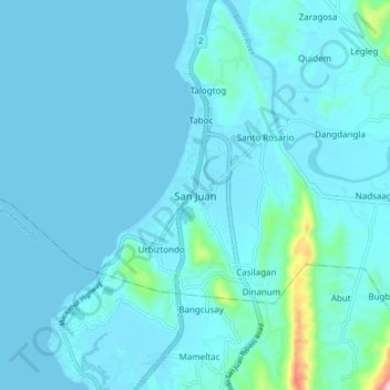
Nome: Mapa topográfico San Juan, altitude, relevo.
Local: San Juan, La Union, Ilocos Region, 2515, Philippines (16.62993 120.29855 16.70993 120.37855)
Altitude média: 21 m
Altitude mínima: -1 m
Altitude máxima: 283 m
Faça uma doação
Outros mapas topográficos
Clique em um mapa para visualizar sua topografia, sua altitude e seu relevo.
Faça uma doação
Rosario
The topography of Rosario is characterized by a valley with mountainous terrain, predominantly shaped by the sharply sloping mountains of the Cordillera Central range, which runs parallel to the coast of the South China Sea. To the west, the land features narrow plains and valleys, interspersed with shallow…
Altitude média: 337 m
Tubao
Rural topography is seventy percent (70%) alluvial plains and thirty percent (30%) uplands. Highest portion is located in Barangay Rizal, which is more than 500 metres (1,600 ft) above sea level along the foothill of Cordillera Central. Flat lands are found in the middle portion of the town, in between its…
Altitude média: 84 m
Faça uma doação
Faça uma doação
Agoo-Damortis Protected Landscape and Seascape
Philippines > La Union > Santo Tomas
Altitude média: 9 m
Faça uma doação
Faça uma doação
Faça uma doação
Aringay
Aringay is a coastal municipality in La Union with a land area of 84.54 square kilometers (32.64 square miles), comprising 5.64% of La Union's total area. The municipality's topography features hilly and mountainous terrains that rise gradually eastward from the coastal plains. Situated at the foothills of the…
Altitude média: 90 m
Agoo
The town's topography is characterized by hilly and mountainous terrain that rises gradually eastward from the coastal plains. Its landscape is also marked by wetlands, scrublands, and grasslands. Mount Katayagan, the highest peak in the town, provides a watershed that supplies water for irrigation and…
Altitude média: 57 m
Faça uma doação
Tubao
Rural topography is seventy percent (70%) alluvial plains and thirty percent (30%) uplands. Highest portion is located in Barangay Rizal, which is more than 500 metres (1,600 ft) above sea level along the foothill of Cordillera Central. Flat lands are found in the middle portion of the town, in between its…
Altitude média: 84 m
Rosario
The topography of Rosario is characterized by a valley with mountainous terrain, predominantly shaped by the sharply sloping mountains of the Cordillera Central range, which runs parallel to the coast of the South China Sea. To the west, the land features narrow plains and valleys, interspersed with shallow…
Altitude média: 337 m
Faça uma doação
Agoo
The town’s topography is characterized by hilly and mountainous terrain that rises gradually eastward from the coastal plains. Its landscape is also marked by wetlands, scrublands, and grasslands. Mount Katayagan, the highest peak in the town, provides a watershed that supplies water for irrigation and…
Altitude média: 57 m
Pugo
The town's topography is predominantly hilly and mountainous, as it is nestled at the foothills of the Mount Santo Tomas (Cordillera Central) a stratovolcano. Lush and peaceful forests cover much of the area, with the terrain rising gradually eastward. Rural areas in the town are characterized by alluvial…
Altitude média: 328 m
San Fernando
The city's topography is characterized by predominantly hilly terrain that gradually rises eastward from the coastal plains. It is traversed by several rivers and creeks, including the Carlatan and Catbangen rivers. The landscape also features scrublands, grasslands, wetlands, and is in proximity to seven…
Altitude média: 68 m
Rosario
The topography of Rosario is characterized by a valley with mountainous terrain, predominantly shaped by the sharply sloping mountains of the Cordillera Central range, which runs parallel to the coast of the South China Sea. To the west, the land features narrow plains and valleys, interspersed with shallow…
Altitude média: 337 m
Faça uma doação