
Faça uma doação
Mapa topográfico Aringay
Clique no mapa para exibir a altitude.
Faça uma doação
Aringay
Aringay is a coastal municipality in La Union with a land area of 84.54 square kilometers (32.64 square miles), comprising 5.64% of La Union's total area. The municipality's topography features hilly and mountainous terrains that rise gradually eastward from the coastal plains. Situated at the foothills of the Cordillera Central, it is home to Salapac Mountain and Mt. Bubon Posi, one of its highest peaks at approximately 325 meters above sea level, visible from multiple vantage points across the town. The area is rich in indigenous trees, natural springs, and the Aringay watershed, a vital resource for the community.
Faça uma doação
Sobre este mapa
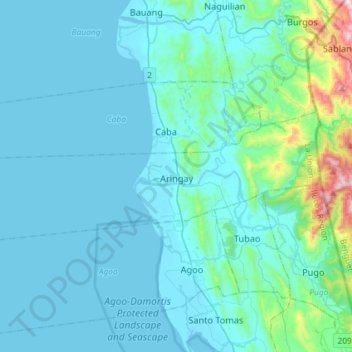
Nome: Mapa topográfico Aringay, altitude, relevo.
Local: Aringay, La Union, Ilocos Region, 2503, Philippines (16.31646 120.17810 16.44780 120.47359)
Altitude média: 90 m
Altitude mínima: -2 m
Altitude máxima: 928 m
Faça uma doação
Outros mapas topográficos
Clique em um mapa para visualizar sua topografia, sua altitude e seu relevo.
Naguilian
The approximate elevation of the municipality is 165 meters above sea level. It has the ninth highest approximate average elevation among the twenty (20) towns of the province. The portion with the highest elevation is 544 meters above sea level while the lowest is 10 meters. The slopes range from 2–7% in…
Altitude média: 85 m
Bacnotan
The topography of the town is characterized by hilly and mountainous terrain rising gradually eastward. The western side of Bacnotan is defined by a long stretch of black sand beaches facing the South China Sea, indicative of the area's abundant magnetite deposits. Certain parts of the coastline also feature…
Altitude média: 21 m
Faça uma doação
Faça uma doação
Faça uma doação
Faça uma doação
Faça uma doação
San Juan
The topography of the town is characterized by hilly and mountainous terrain that gradually rises eastward from its coastal plains along the foothills of the Cordillera Central. The town is also traversed by several creeks and rivers, with the Baroro River being the most prominent.
Altitude média: 21 m
Faça uma doação
Faça uma doação
San Gabriel
The Municipality of San Gabriel is recognized as the largest municipality by land area in La Union. The town’s topography is predominantly mountainous, gradually ascending eastward, with a mix of scrubland, grassland, and wetland ecosystems. Its landscape is traversed by the Baroro River, the town's major…
Altitude média: 131 m
Faça uma doação
Faça uma doação
Agoo-Damortis Protected Landscape and Seascape
Philippines > La Union > Santo Tomas
Altitude média: 9 m
Faça uma doação
Faça uma doação
Faça uma doação
Faça uma doação
Faça uma doação
Faça uma doação
Faça uma doação
Faça uma doação
Faça uma doação
Faça uma doação
Faça uma doação
Faça uma doação
Faça uma doação
Faça uma doação
Faça uma doação
Faça uma doação