
Faça uma doação
Mapa topográfico Northumberland County
Clique no mapa para exibir a altitude.
Faça uma doação
Sobre este mapa
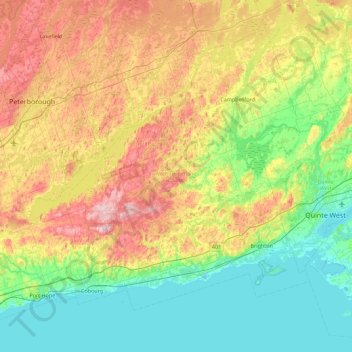
Nome: Mapa topográfico Northumberland County, altitude, relevo.
Local: Northumberland County, Central Ontario, Ontario, Canada (43.89892 -78.50851 44.43647 -77.61487)
Altitude média: 165 m
Altitude mínima: 71 m
Altitude máxima: 355 m
Faça uma doação
Outros mapas topográficos
Clique em um mapa para visualizar sua topografia, sua altitude e seu relevo.
Toronto
Despite its deep ravines, Toronto is not remarkably hilly, but its elevation does increase steadily away from the lake. Elevation differences range from 76.5 metres (251 ft) above sea level at the Lake Ontario shore to 209 m (686 ft) ASL near the York University grounds in the city's north end at the…
Altitude média: 113 m
London
Canada > Ontario > London > London
London has a humid continental climate (Köppen Dfb), though due to its downwind location relative to Lake Huron and elevation changes across the city, it is virtually on the Dfa/Dfb (hot summer) boundary favouring the former climate zone to the southwest of the confluence of the South and North Thames Rivers,…
Altitude média: 268 m
Peterborough
Canada > Ontario > Peterborough
Peterborough's topography is largely defined by land formations created by the receding Wisconsian glaciers 10,000–15,000 years ago. The South End and Downtown portions of the City sit on what was the bottom of the glacial Lake Peterborough—part of a glacial spillway created when glacial meltwaters from…
Altitude média: 235 m
Faça uma doação
Guelph
This region of Ontario has cold winters and warm, humid summers, falling into the Köppen climate classification Dfb zone, with moderately high rainfall and snowfall. It is generally a couple of degrees cooler than lower elevation regions on the Great Lakes shorelines, especially so in winter, the exception…
Altitude média: 344 m
Faça uma doação
Faça uma doação
Faça uma doação
Madawaska River
Canada > Ontario > Renfrew County > Greater Madawaska > Calabogie
Altitude média: 160 m
Faça uma doação
Faça uma doação
Faça uma doação
Faça uma doação
Nestor Falls
Canada > Ontario > Kenora District > Sioux Narrows-Nestor Falls Township
Altitude média: 337 m
Faça uma doação
Faça uma doação
Queenston Heights Park
Canada > Ontario > Niagara Region > Niagara-on-the-Lake > Queenston
Altitude média: 139 m
Faça uma doação
Faça uma doação
Faça uma doação
Faça uma doação
Faça uma doação
Faça uma doação
London
London has a humid continental climate (Köppen Dfb), though due to its downwind location relative to Lake Huron and elevation changes across the city, it is virtually on the Dfa/Dfb (hot summer) boundary favouring the former climate zone to the southwest of the confluence of the South and North Thames Rivers,…
Altitude média: 269 m
Faça uma doação
Faça uma doação
Faça uma doação
Faça uma doação
Faça uma doação
Weslemkoon Lake
Canada > Ontario > Lennox and Addington County > Addington Highlands
Altitude média: 324 m
Faça uma doação
Faça uma doação
Moose Creek
Canada > Ontario > Stormont, Dundas and Glengarry Counties > North Stormont
Altitude média: 87 m
Faça uma doação
Faça uma doação