
Obrigado por apoiar este site ❤️
Faça uma doação
Faça uma doação
Mapa topográfico Otonabee River
Clique no mapa para exibir a altitude.
Obrigado por apoiar este site ❤️
Faça uma doação
Faça uma doação
Sobre este mapa
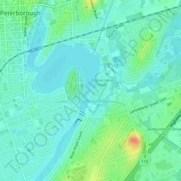
Nome: Mapa topográfico Otonabee River, altitude, relevo.
Local: Otonabee River, Peterborough, Ontario, K9H 7N9, Canada (44.28918 -78.30737 44.29724 -78.30532)
Altitude média: 197 m
Altitude mínima: 186 m
Altitude máxima: 229 m
Obrigado por apoiar este site ❤️
Faça uma doação
Faça uma doação
Outros mapas topográficos
Clique em um mapa para visualizar sua topografia, sua altitude e seu relevo.
Peterborough
Canada > Ontario > Peterborough
Peterborough's topography is largely defined by land formations created by the receding Wisconsian glaciers 10,000–15,000 years ago. The South End and Downtown portions of the City sit on what was the bottom of the glacial Lake Peterborough—part of a glacial spillway created when glacial meltwaters from…
Altitude média: 235 m