
Faça uma doação
Mapa topográfico Pacific Palisades
Clique no mapa para exibir a altitude.
Faça uma doação
Pacific Palisades
Pacific Palisades was formally founded in 1921 by a Methodist organization, and in the years that followed became a refuge for Jewish artists and intellectuals fleeing the Holocaust. The Palisades would later be sought after by celebrities and other high-profile individuals seeking privacy. It is known for its seclusion and for being a close-knit community with a small-town feel, as well as its Mediterranean climate, hilly topography, natural environment, and abundance of parkland and hiking trails, 3-mile (4.8 km) strip of coastline, and for being home to a number of architecturally significant homes.
Faça uma doação
Sobre este mapa
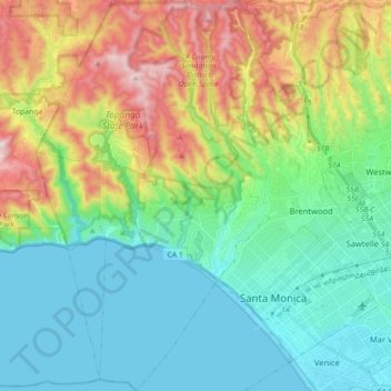
Nome: Mapa topográfico Pacific Palisades, altitude, relevo.
Altitude média: 196 m
Altitude mínima: -2 m
Altitude máxima: 653 m
Faça uma doação
Outros mapas topográficos
Clique em um mapa para visualizar sua topografia, sua altitude e seu relevo.
Universal City Overlook
United States > California > Los Angeles County > Los Angeles
Altitude média: 278 m
San Fernando Valley
United States > California > Los Angeles County > Los Angeles
Altitude média: 496 m
Faça uma doação
Will Rogers State Historic Park
United States > California > Los Angeles County > Los Angeles
Altitude média: 152 m
Faça uma doação
San Fernando Valley
United States > California > Los Angeles County > Los Angeles
Altitude média: 496 m
Faça uma doação
Rio de Los Angeles State Park State Recreational Area
United States > California > Los Angeles County > Los Angeles
Altitude média: 141 m
Faça uma doação