
Faça uma doação
Mapa topográfico Gmunden
Clique no mapa para exibir a altitude.
Faça uma doação
Gmunden
Gmunden covers an area of 63.49 square kilometres (24.51 sq mi) and has a median elevation of 425 metres (1,394 ft). It is situated next to the lake Traunsee on the Traun River and is surrounded by high mountains, including the Traunstein (5,446 feet; 1,660 m), the Erlakogel (5,150 feet; 1,570 m), the Wilder Kogel (6,860 feet; 2,090 m) and the Höllengebirge.
Faça uma doação
Sobre este mapa
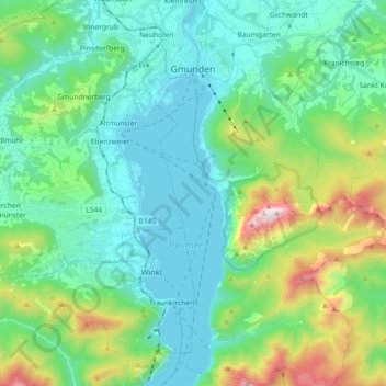
Nome: Mapa topográfico Gmunden, altitude, relevo.
Local: Gmunden, Bezirk Gmunden, Upper Austria, 4810, Austria (47.81858 13.77477 47.94020 13.90030)
Altitude média: 692 m
Altitude mínima: 414 m
Altitude máxima: 1.645 m
Faça uma doação
Outros mapas topográficos
Clique em um mapa para visualizar sua topografia, sua altitude e seu relevo.
Hoher Dachstein
Austria > Upper Austria > Bezirk Gmunden > Gosau
The Dachstein massif covers an area of around 600 square kilometres (230 sq mi) with dozens of peaks above 2,500 m, the highest of which are in the southern and southwestern areas. The main summit of the Hoher Dachstein is at an elevation of 2,997 metres (9,833 ft). Seen from the north, the Dachstein massif is…
Altitude média: 2.341 m
Faça uma doação
Predigstuhl
Austria > Upper Austria > Bezirk Gmunden > Bad Goisern am Hallstättersee
Altitude média: 921 m
Bad Goisern
Austria > Upper Austria > Bezirk Gmunden > Bad Goisern am Hallstättersee > Bad Goisern
Altitude média: 644 m
Faça uma doação
Faça uma doação