
Faça uma doação
Mapa topográfico Liguanea Island
Clique no mapa para exibir a altitude.
Faça uma doação
Liguanea Island
Liguanea Island is an uninhabited granite island in the Australian state of South Australia located 3.7 km south of Cape Carnot at the southern, central point of Eyre Peninsula. It is approximately 2.7 km long, 180 ha in size its elevation above sea level is estimated to be 43 metres.[1] It is approximately 35 km south-west of Port Lincoln in the Great Australian Bight.[2] The island forms part of the Lincoln National Park.[3]
Faça uma doação
Sobre este mapa
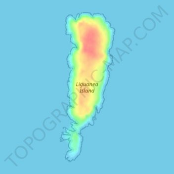
Nome: Mapa topográfico Liguanea Island, altitude, relevo.
Altitude média: 4 m
Altitude mínima: 0 m
Altitude máxima: 55 m
Faça uma doação
Outros mapas topográficos
Clique em um mapa para visualizar sua topografia, sua altitude e seu relevo.
Adelaide
Australia > South Australia > Adelaide
Adelaide is north of the Fleurieu Peninsula, on the Adelaide Plains between the Gulf St Vincent and the low-lying Mount Lofty Ranges. The city stretches 20 km (12 mi) from the coast to the foothills, and 90 km (56 mi) from Gawler at its northern extent to Sellicks Beach in the south. According to the Regional…
Altitude média: 148 m
Lake Eyre (North)
The −15 m (−49 ft) altitude usually attributed to Kati Thanda–Lake Eyre refers to the deepest parts of the lake floor, in Belt Bay and the Madigan Gulf. The shoreline lies at −9 m (−30 ft). The lake is the area of maximum deposition of sediment in the Lake Eyre Basin.
Altitude média: 2 m
Faça uma doação
Angaston
Angaston is a town on the eastern side of the Barossa Valley in South Australia, 77 km northeast of Adelaide. Its elevation is 347 m, one of the highest points in the valley, and has an average rainfall of 561 mm. Angaston was originally known as German Pass, but was later renamed after the politician, banker…
Altitude média: 397 m
Gawler
Gawler is the oldest country town on the Australian mainland in the state of South Australia. It was named after the second Governor (British Vice-Regal representative) of the colony of South Australia, George Gawler. It is about 40–44 km (25–27 mi) north of the centre of the state capital, Adelaide, and…
Altitude média: 63 m
Faça uma doação
Wapma Thura-Southern Flinders Ranges National Park
Australia > South Australia > Wirrabara
Altitude média: 295 m
Faça uma doação
Faça uma doação
Mount Barker
Australia > South Australia > Mount Barker District Council
Mount Barker is located on the plains surrounding the Mount Barker Summit, about 2 km west of the mountain, at 35°04′S 138°51′E / 35.067°S 138.850°E / -35.067; 138.850. Mount Barker is south east of Mount Lofty and Adelaide. It is north of The Coorong, and the west of Murray Bridge. Mount…
Altitude média: 368 m
Faça uma doação
Faça uma doação
Faça uma doação
Munga-Thirri—Simpson Desert National Park
Australia > South Australia > Pastoral Unincorporated Area
Altitude média: 41 m
Faça uma doação
Lake Dey-Dey
Australia > South Australia > Maralinga Tjarutja
The surface of the lake normally consists of dry clay, silt or sand, covered with a salty crust. The area around Lake Dey Dey is extremely arid, and groundwater contains high levels of salinity. The elevation of the surface above mean sea level is 208 m (682 ft).
Altitude média: 219 m
Faça uma doação
Oodnadatta
Australia > South Australia > Pastoral Unincorporated Area
Oodnadatta is a small, remote outback town and locality in the Australian state of South Australia, located 1043 kilometres (648 miles) north-north-west of the state capital of Adelaide by road or 873 km (542 mi) direct, at an altitude of 112 metres (367 feet). The unsealed Oodnadatta Track, an outback road…
Altitude média: 130 m
Faça uma doação
Stirling
Many deciduous trees, particularly the maple, elm, oak and ash trees, have been imported from Europe and North America. These trees flourish in Stirling's wet and mild to cool climate and are a popular tourist attraction in the autumn months (April–May), bringing rich and vibrant autumn leaf colour to the…
Altitude média: 504 m
Faça uma doação
Faça uma doação
Lyndoch
Lyndoch is a town in Barossa Valley, located on the Barossa Valley Highway between Gawler and Tanunda, 58 km northeast of Adelaide. The town has an elevation of 175m and an average rainfall of 560.5mm. It is one of the oldest towns in South Australia.
Altitude média: 216 m
Faça uma doação
Gawler
Australia > South Australia > Gawler
Gawler is the oldest country town on the Australian mainland in the state of South Australia. It was named after the second Governor (British Vice-Regal representative) of the colony of South Australia, George Gawler. It is about 40–44 km (25–27 mi) north of the centre of the state capital, Adelaide, and…
Altitude média: 142 m
Faça uma doação
Faça uma doação
Moomba Gas and Oil Field
Australia > South Australia > Pastoral Unincorporated Area > Moomba Gas and Oil Field
Altitude média: 36 m
Olympic Dam
Australia > South Australia > Municipal Council of Roxby Downs > Olympic Dam
Altitude média: 104 m
Faça uma doação
The District Council of Coober Pedy
Australia > South Australia > The District Council of Coober Pedy
Altitude média: 205 m
Faça uma doação
Faça uma doação
Adelaide (Sellicks Hill) Weather Radar
Australia > South Australia > City of Onkaparinga > Adelaide
Altitude média: 291 m
Faça uma doação
Faça uma doação
Riverglades
Australia > South Australia > The Rural City of Murray Bridge > Riverglades
Altitude média: 27 m
Faça uma doação
Faça uma doação
Faça uma doação
Bookpurnong
Australia > South Australia > The District Council of Loxton Waikerie
Altitude média: 37 m