
Mapa topográfico Gawler
Clique no mapa para exibir a altitude.
Gawler
Gawler is the oldest country town on the Australian mainland in the state of South Australia. It was named after the second Governor (British Vice-Regal representative) of the colony of South Australia, George Gawler. It is about 40–44 km (25–27 mi) north of the centre of the state capital, Adelaide, and is close to the major wine producing district of the Barossa Valley. Topographically, Gawler lies at the confluence of two tributaries of the Gawler River, the North and South Para rivers, where they emerge from a range of low hills.
Sobre este mapa
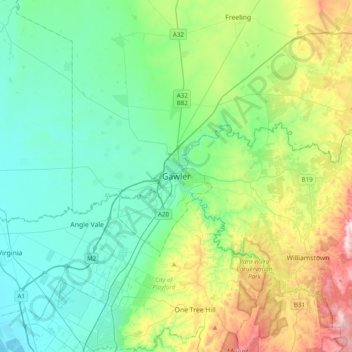
Nome: Mapa topográfico Gawler, altitude, relevo.
Altitude média: 142 m
Altitude mínima: 2 m
Altitude máxima: 564 m