
Mapa topográfico Blalock
Mapa interativo
Clique no mapa para exibir a altitude.
Sobre este mapa
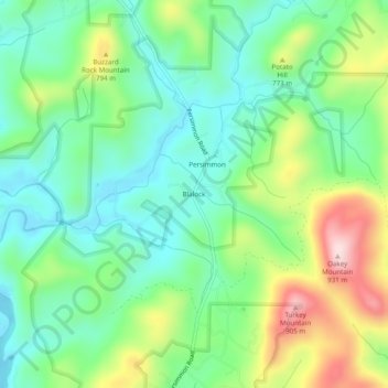
Nome: Mapa topográfico Blalock, altitude, relevo.
Local: Blalock, Rabun County, Georgia, United States (34.87315 -83.53350 34.91315 -83.49350)
Altitude média: 682 m
Altitude mínima: 569 m
Altitude máxima: 914 m
Outros mapas topográficos
Clique em um mapa para visualizar sua topografia, sua altitude e seu relevo.
Mountain City
United States > Georgia > Rabun County
Mountain City, Rabun County, Georgia, 30562, United States
Altitude média: 747 m
Chestnut Mountain
United States > Georgia > Rabun County
Chestnut Mountain, Rabun County, Georgia, 30537, United States
Altitude média: 834 m
Clayton
United States > Georgia > Rabun County
Clayton, Rabun County, Georgia, 30525, United States
Altitude média: 621 m
Sky Valley
United States > Georgia > Rabun County
Sky Valley, Rabun County, Georgia, 30537, United States
Altitude média: 973 m
Elisha Mountain
United States > Georgia > Rabun County
Elisha Mountain, Rabun County, Georgia, 30525, United States
Altitude média: 828 m
Lake Burton
United States > Georgia > Rabun County
Lake Burton, Rabun County, Georgia, United States
Altitude média: 662 m
Black Rock Mountain State Park
United States > Georgia > Rabun County > Mountain City
Black Rock Mountain State Park, Mountain City, Rabun County, Georgia, United States
Altitude média: 833 m
Tallulah Gorge State Park
United States > Georgia > Rabun County > Tallulah Falls
Tallulah Gorge State Park, Tallulah Falls, Rabun County, Georgia, United States
Altitude média: 435 m
Tallulah Gorge
United States > Georgia > Rabun County > Tallulah Falls
Tallulah Gorge, Tallulah Falls, Rabun County, Georgia, United States
Altitude média: 465 m
Lakemont
United States > Georgia > Rabun County
Lakemont, Rabun County, Georgia, 30581, United States
Altitude média: 547 m
Dillard
United States > Georgia > Rabun County
Dillard, Rabun County, Georgia, United States
Altitude média: 691 m
Rabun Gap Nacoochee School Lake
United States > Georgia > Rabun County
Rabun Gap Nacoochee School Lake, Rabun County, Georgia, United States
Altitude média: 671 m
Ben Mountain
United States > Georgia > Rabun County
Ben Mountain, Rabun County, Georgia, 30537, United States
Altitude média: 866 m
Rabun Gap Nacoochee School Lake Dam
United States > Georgia > Rabun County
Rabun Gap Nacoochee School Lake Dam, Rabun County, Georgia, 30568, United States
Altitude média: 671 m
Lake Seed
United States > Georgia > Rabun County
Lake Seed, Rabun County, Georgia, United States
Altitude média: 653 m