
Mapa topográfico Bentonville
Mapa interativo
Clique no mapa para exibir a altitude.
Sobre este mapa
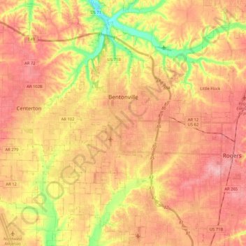
Nome: Mapa topográfico Bentonville, altitude, relevo.
Local: Bentonville, Benton County, Arkansas, United States (36.27106 -94.32624 36.43871 -94.15459)
Altitude média: 387 m
Altitude mínima: 309 m
Altitude máxima: 436 m
Bentonville lies in the humid subtropical climate zone (Köppen Cfa) with influence from the humid continental climate type. Bentonville experiences all four seasons and does receive cold air masses from the north, however some of the Arctic masses are blocked by the higher elevations of the Ozarks. July is the hottest month of the year, with an average high of 89 °F (32 °C) and an average low of 66 °F (19 °C). Temperatures above 90 °F (32.2 °C) are common, with a high of 100 °F (37.8 °C) occurring about once per year on average. January is the coldest month with an average high of 46 °F (8 °C) and an average low of 24 °F (−4 °C). The city's highest temperature was 114 °F (45.6 °C), recorded in 1954. The lowest temperature recorded was −16 °F (−26.7 °C), in 1996.
Outros mapas topográficos
Clique em um mapa para visualizar sua topografia, sua altitude e seu relevo.
Rogers
United States > Arkansas > Benton County
Rogers, Benton County, Arkansas, United States
Altitude média: 393 m
Beaver Lake
United States > Arkansas > Benton County > Goshen
Beaver Lake, Goshen, Benton County, Arkansas, 72757, United States
Altitude média: 394 m
Lost Bridge Village
United States > Arkansas > Benton County
Lost Bridge Village, Benton County, Arkansas, United States
Altitude média: 377 m
Maysville
United States > Arkansas > Benton County
Maysville, Benton County, Arkansas, 72747, United States
Altitude média: 323 m
Decatur
United States > Arkansas > Benton County
Decatur, Benton County, Arkansas, 72722, United States
Altitude média: 379 m
Gateway
United States > Arkansas > Benton County
Gateway, Benton County, Arkansas, 72733, United States
Altitude média: 467 m
Little Flock
United States > Arkansas > Benton County
Little Flock, Benton County, Arkansas, United States
Altitude média: 388 m
Springtown
United States > Arkansas > Benton County
Springtown, Benton County, Arkansas, 72734, United States
Altitude média: 388 m
Siloam Springs
United States > Arkansas > Benton County
Siloam Springs, Benton County, Arkansas, 72761, United States
Altitude média: 339 m
Hiwasse
United States > Arkansas > Benton County > Gravette
Hiwasse, Gravette, Benton County, Arkansas, 72739, United States
Altitude média: 394 m
Bella Vista
United States > Arkansas > Benton County
Bella Vista, Benton County, Arkansas, 72715, United States
Altitude média: 372 m
Benton Country Fair Grounds
United States > Arkansas > Benton County > Bentonville
Benton Country Fair Grounds, Bentonville, Benton County, Arkansas, United States
Altitude média: 384 m
Lake Avalon
United States > Arkansas > Benton County > Bella Vista
Lake Avalon, Bella Vista, Benton County, Arkansas, 72715, United States
Altitude média: 353 m
Rago
United States > Arkansas > Benton County > Bella Vista
Rago, Bella Vista, Benton County, Arkansas, 72715, United States
Altitude média: 378 m
Loch Lomond
United States > Arkansas > Benton County > Bella Vista
Loch Lomond, Bella Vista, Benton County, Arkansas, 72715, United States
Altitude média: 360 m
Dug Hill
United States > Arkansas > Benton County > Bella Vista
Dug Hill, Bella Vista, Benton County, Arkansas, 72715, United States
Altitude média: 344 m
Centerton
United States > Arkansas > Benton County
Centerton, Benton County, Arkansas, 72719, United States
Altitude média: 393 m
Pedro
United States > Arkansas > Benton County
Pedro, Benton County, Arkansas, United States
Altitude média: 334 m
Lake Windsor
United States > Arkansas > Benton County > Bella Vista
Lake Windsor, Bella Vista, Benton County, Arkansas, 72715, United States
Altitude média: 352 m
Silent Grove
United States > Arkansas > Benton County > Springdale
Silent Grove, Springdale, Benton County, Arkansas, 72762, United States
Altitude média: 394 m
Cave Springs
United States > Arkansas > Benton County
Cave Springs, Benton County, Arkansas, 72718, United States
Altitude média: 375 m
Gravette
United States > Arkansas > Benton County
Gravette, Benton County, Arkansas, United States
Altitude média: 356 m
Siloam Springs Lake
United States > Arkansas > Benton County > Siloam Springs
Siloam Springs Lake, Siloam Springs, Benton County, Arkansas, United States
Altitude média: 341 m
Healing Springs
United States > Arkansas > Benton County
Healing Springs, Benton County, Arkansas, United States
Altitude média: 365 m
Garfield
United States > Arkansas > Benton County
Garfield, Benton County, Arkansas, 72732, United States
Altitude média: 453 m
Oak Grove
United States > Arkansas > Benton County > Oak Grove
Oak Grove, Benton County, Arkansas, 72757, United States
Altitude média: 362 m
Lake Springdale
United States > Arkansas > Benton County > Springdale
Lake Springdale, Springdale, Benton County, Arkansas, United States
Altitude média: 392 m
Lowell
United States > Arkansas > Benton County
Lowell, Benton County, Arkansas, United States
Altitude média: 404 m
Sulphur Springs
United States > Arkansas > Benton County
Sulphur Springs, Benton County, Arkansas, United States
Altitude média: 308 m
Gentry
United States > Arkansas > Benton County
Gentry, Benton County, Arkansas, 72734, United States
Altitude média: 371 m
Bella Vista
United States > Arkansas > Benton County > Bella Vista > Bella Vista
Bella Vista, Benton County, Arkansas, 72715, United States
Altitude média: 359 m
Garfield
United States > Arkansas > Benton County > Garfield
Garfield, Benton County, Arkansas, 72732, United States
Altitude média: 453 m
Pea Ridge
United States > Arkansas > Benton County
Pea Ridge, Benton County, Arkansas, 72751, United States
Altitude média: 393 m