
Mapa topográfico Lake Windsor
Mapa interativo
Clique no mapa para exibir a altitude.
Sobre este mapa
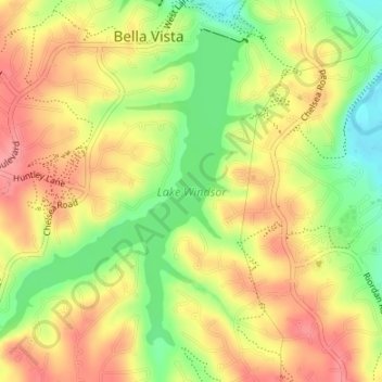
Nome: Mapa topográfico Lake Windsor, altitude, relevo.
Altitude média: 352 m
Altitude mínima: 302 m
Altitude máxima: 391 m
Outros mapas topográficos
Clique em um mapa para visualizar sua topografia, sua altitude e seu relevo.
Lake Avalon
United States > Arkansas > Benton County > Bella Vista
Lake Avalon, Bella Vista, Benton County, Arkansas, 72715, United States
Altitude média: 353 m
Rago
United States > Arkansas > Benton County > Bella Vista
Rago, Bella Vista, Benton County, Arkansas, 72715, United States
Altitude média: 378 m
Loch Lomond
United States > Arkansas > Benton County > Bella Vista
Loch Lomond, Bella Vista, Benton County, Arkansas, 72715, United States
Altitude média: 360 m
Dug Hill
United States > Arkansas > Benton County > Bella Vista
Dug Hill, Bella Vista, Benton County, Arkansas, 72715, United States
Altitude média: 344 m
Bella Vista
United States > Arkansas > Benton County > Bella Vista > Bella Vista
Bella Vista, Benton County, Arkansas, 72715, United States
Altitude média: 359 m