
Mapa topográfico Wildeck
Clique no mapa para exibir a altitude.
Sobre este mapa
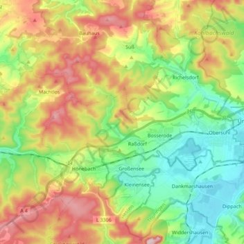
Nome: Mapa topográfico Wildeck, altitude, relevo.
Local: Wildeck, Landkreis Hersfeld-Rotenburg, Hesse, 36208, Germany (50.91509 9.89623 50.99653 10.06485)
Altitude média: 330 m
Altitude mínima: 208 m
Altitude máxima: 508 m
Outros mapas topográficos
Clique em um mapa para visualizar sua topografia, sua altitude e seu relevo.
Bad Hersfeld
Germany > Hesse > Landkreis Hersfeld-Rotenburg
The Flugplatz Johannesberg has the status of Special Airfield. The runway, some 671 m long and 18 m wide, is paved with asphalt and oriented in a north–south direction. The airfield lies on the Johannesberg in the like-named outlying centre at an elevation of 284 m above sea level.
Altitude média: 281 m