
Mapa topográfico Bad Hersfeld
Mapa interativo
Clique no mapa para exibir a altitude.
Bad Hersfeld
The Flugplatz Johannesberg has the status of Special Airfield. The runway, some 671 m long and 18 m wide, is paved with asphalt and oriented in a north–south direction. The airfield lies on the Johannesberg in the like-named outlying centre at an elevation of 284 m above sea level.
Sobre este mapa
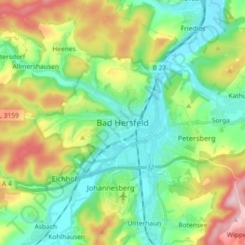
Nome: Mapa topográfico Bad Hersfeld, altitude, relevo.
Altitude média: 281 m
Altitude mínima: 193 m
Altitude máxima: 466 m
Outros mapas topográficos
Clique em um mapa para visualizar sua topografia, sua altitude e seu relevo.
Hohenroda
Germany > Hesse > Landkreis Hersfeld-Rotenburg
The municipality lies between the Rhön and the Thuringian Forest (ranges) in the so-called Kuppen Rhön. The highest elevation in the Hessian Skittles (a range of volcanic mountains), the Soisberg, stands at the western municipal limits.
Altitude média: 341 m
Bad Hersfeld
Germany > Hesse > Landkreis Hersfeld-Rotenburg
The Flugplatz Johannesberg has the status of Special Airfield. The runway, some 671 m long and 18 m wide, is paved with asphalt and oriented in a north-south direction. The airfield lies on the Johannesberg in the like-named outlying centre at an elevation of 284 m above sea level.
Altitude média: 305 m