
Obrigado por apoiar este site ❤️
Faça uma doação
Faça uma doação
Mapa topográfico Bailén-Miraflores
Clique no mapa para exibir a altitude.
Obrigado por apoiar este site ❤️
Faça uma doação
Faça uma doação
Sobre este mapa
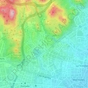
Nome: Mapa topográfico Bailén-Miraflores, altitude, relevo.
Altitude média: 79 m
Altitude mínima: 10 m
Altitude máxima: 244 m
Obrigado por apoiar este site ❤️
Faça uma doação
Faça uma doação
Outros mapas topográficos
Clique em um mapa para visualizar sua topografia, sua altitude e seu relevo.
Málaga
Spain > Andalusia > Málaga-Costa del Sol > Málaga
Like many of the military fortifications that were constructed in Islamic Spain, the Alcazaba of Málaga featured a quadrangular plan. It was protected by an outer and inner wall, both supported by rectangular towers, between which a covered walkway led up the slope to the Gibralfaro (this was the only…
Altitude média: 215 m