
Faça uma doação
Mapa topográfico Málaga
Clique no mapa para exibir a altitude.
Faça uma doação
Málaga
Like many of the military fortifications that were constructed in Islamic Spain, the Alcazaba of Málaga featured a quadrangular plan. It was protected by an outer and inner wall, both supported by rectangular towers, between which a covered walkway led up the slope to the Gibralfaro (this was the only exchange between the two sites). Due to its rough and awkward hillside topography, corridors throughout the site provided a means of communications for administrative and defensive operations, also affording privacy to the palatial residential quarters.
Faça uma doação
Sobre este mapa
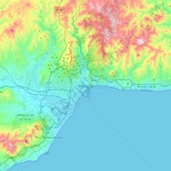
Nome: Mapa topográfico Málaga, altitude, relevo.
Local: Málaga, Málaga-Costa del Sol, Malaga, Andalusia, 29008, Spain (36.56130 -4.58164 36.88130 -4.26164)
Altitude média: 215 m
Altitude mínima: -1 m
Altitude máxima: 1.019 m
Faça uma doação
Outros mapas topográficos
Clique em um mapa para visualizar sua topografia, sua altitude e seu relevo.
Faça uma doação
Faça uma doação
Faça uma doação
Faça uma doação