
Faça uma doação
Mapa topográfico Buena Vista
Clique no mapa para exibir a altitude.
Faça uma doação
Buena Vista
Buena Vista is located in central Colorado roughly midway between Salida and Leadville in the Upper Arkansas River Valley at an elevation of 7,965 feet (2,428 m). The area between Buena Vista and Salida is often referred to as the Denver & Rio Grande, South Park & Pacific, and Colorado Midland railroads. Many of the existing buildings of Buena Vista date back to this era, and were built in the 1880s and 1890s.
Faça uma doação
Sobre este mapa
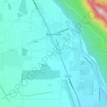
Nome: Mapa topográfico Buena Vista, altitude, relevo.
Altitude média: 2.457 m
Altitude mínima: 2.389 m
Altitude máxima: 2.877 m
Faça uma doação
Outros mapas topográficos
Clique em um mapa para visualizar sua topografia, sua altitude e seu relevo.
Buena Vista
United States > Colorado > Chaffee County
Buena Vista is located in central Colorado roughly midway between Salida and Leadville in the Upper Arkansas River Valley at an elevation of 7,965 feet (2,428 m). The area between Buena Vista and Salida is often referred to as the Denver & Rio Grande, South Park & Pacific, and Colorado Midland railroads. Many…
Altitude média: 2.457 m
Faça uma doação
Mount Harvard
United States > Colorado > Chaffee County
In 1962, three Harvard men attempted to erect a fourteen-foot metal pole on the top of Harvard, with a sign that read "Mt. Harvard, 14,434. This sign erected at an altitude of 14,434 making it the second highest point in the contiguous United States." Before they could reach the top of the mountain darkness…
Altitude média: 3.936 m
Faça uma doação
Faça uma doação
Faça uma doação
Cottonwood Pass
United States > Colorado > Chaffee County
Cottonwood Pass (elevation 12,119 feet (3,694 m)) is a high mountain pass on the Continental Divide in south-central Colorado in the Rocky Mountains of the western United States. It is located along the border of Gunnison and Chaffee counties in Colorado, and is in the Sawatch Range. The road over Cottonwood…
Altitude média: 3.631 m
Faça uma doação
La Plata Peak
United States > Colorado > Chaffee County
The elevation of 14,361 feet marked on the USGS Mount Elbert Quadrangle is incorrect, and should read 14,336 feet (in the NGVD 29 vertical datum).
Altitude média: 3.880 m
Faça uma doação
Buena Vista
United States > Colorado > Chaffee County
Buena Vista is located in central Colorado roughly midway between Salida and Leadville in the Upper Arkansas River Valley at an elevation of 7,965 feet (2,428 m). The area between Buena Vista and Salida is often referred to as the Denver & Rio Grande, South Park & Pacific, and Colorado Midland railroads. Many…
Altitude média: 2.457 m
Faça uma doação