
Faça uma doação
Mapa topográfico Maysville
Clique no mapa para exibir a altitude.
Faça uma doação
Sobre este mapa
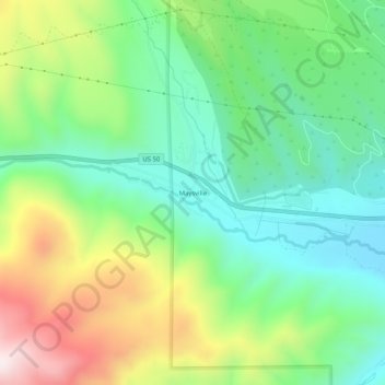
Nome: Mapa topográfico Maysville, altitude, relevo.
Local: Maysville, Chaffee County, Colorado, United States (38.51861 -106.21030 38.55861 -106.17030)
Altitude média: 2.687 m
Altitude mínima: 2.445 m
Altitude máxima: 3.138 m
Faça uma doação
Outros mapas topográficos
Clique em um mapa para visualizar sua topografia, sua altitude e seu relevo.
Buena Vista
United States > Colorado > Chaffee County
Buena Vista is located in central Colorado roughly midway between Salida and Leadville in the Upper Arkansas River Valley at an elevation of 7,965 feet (2,428 m). The area between Buena Vista and Salida is often referred to as the Denver & Rio Grande, South Park & Pacific, and Colorado Midland railroads. Many…
Altitude média: 2.457 m
Saint Elmo
United States > Colorado > Chaffee County
Saint Elmo is a ghost town in Chaffee County, Colorado, United States. Founded in 1880, Saint Elmo lies in the heart of the Sawatch Range, 20 miles (32 km) southwest of Buena Vista and sits at an elevation of 9,961 feet (3,036 m). Nearly 2,000 people settled in this town when mining for gold and silver…
Altitude média: 3.247 m
Faça uma doação
Faça uma doação
Buena Vista
United States > Colorado > Chaffee County
Buena Vista is located in central Colorado roughly midway between Salida and Leadville in the Upper Arkansas River Valley at an elevation of 7,965 feet (2,428 m). The area between Buena Vista and Salida is often referred to as the Denver & Rio Grande, South Park & Pacific, and Colorado Midland railroads. Many…
Altitude média: 2.457 m
Faça uma doação
Buena Vista
United States > Colorado > Chaffee County
Buena Vista is located in central Colorado roughly midway between Salida and Leadville in the Upper Arkansas River Valley at an elevation of 7,965 feet (2,428 m). The area between Buena Vista and Salida is often referred to as the Denver & Rio Grande, South Park & Pacific, and Colorado Midland railroads. Many…
Altitude média: 2.457 m