
Faça uma doação
Mapa topográfico Utah Lake
Clique no mapa para exibir a altitude.
Faça uma doação
Utah Lake
Utah Lake is a shallow freshwater lake in the center of Utah County, Utah, United States. It lies in Utah Valley, surrounded by the Provo-Orem metropolitan area. The lake's only river outlet, the Jordan River, is a tributary of the Great Salt Lake. Evaporation accounts for 42% of the lake's outflow, which leaves the lake slightly saline. The elevation of the lake is at 4,489 feet (1,368 m) above sea level. If the lake's water level rises above that, the pumps and gates on the Jordan River are left open. Recently the lake has been at a lower level because of a drought.
Faça uma doação
Sobre este mapa
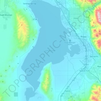
Nome: Mapa topográfico Utah Lake, altitude, relevo.
Local: Utah Lake, Utah County, Utah, United States (40.00922 -111.94295 40.36121 -111.67254)
Altitude média: 1.512 m
Altitude mínima: 1.364 m
Altitude máxima: 3.293 m
Faça uma doação
Outros mapas topográficos
Clique em um mapa para visualizar sua topografia, sua altitude e seu relevo.
Faça uma doação
Saratoga Springs Park
United States > Utah > Utah County > Saratoga Springs > Saratoga Resort
Altitude média: 1.375 m
Faça uma doação