
Faça uma doação
Mapa topográfico Birdseye
Clique no mapa para exibir a altitude.
Faça uma doação
Sobre este mapa
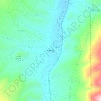
Nome: Mapa topográfico Birdseye, altitude, relevo.
Local: Birdseye, Utah County, Utah, United States (39.90440 -111.56964 39.94440 -111.52964)
Altitude média: 1.780 m
Altitude mínima: 1.625 m
Altitude máxima: 2.278 m
Faça uma doação
Outros mapas topográficos
Clique em um mapa para visualizar sua topografia, sua altitude e seu relevo.
Utah Lake
United States > Utah > Utah County
Utah Lake is a shallow freshwater lake in the center of Utah County, Utah, United States. It lies in Utah Valley, surrounded by the Provo-Orem metropolitan area. The lake's only river outlet, the Jordan River, is a tributary of the Great Salt Lake. Evaporation accounts for 42% of the lake's outflow, which…
Altitude média: 1.512 m
Faça uma doação
Faça uma doação
Lone Peak Wilderness
United States > Utah > Utah County > Alpine
The Lone Peak Wilderness provides a spectacular backdrop for the growing urban areas along the Wasatch Front and is dominated by rugged terrain, narrow canyons and high peaks, including the Pfeifferhorn, commonly referred to as Little Matterhorn Peak, at 11,326 feet (3,452 m) and Lone Peak at 11,253 feet…
Altitude média: 2.367 m
Saratoga Springs Park
United States > Utah > Utah County > Saratoga Springs > Saratoga Resort
Altitude média: 1.375 m