
Mapa topográfico Berea
Mapa interativo
Clique no mapa para exibir a altitude.
Sobre este mapa
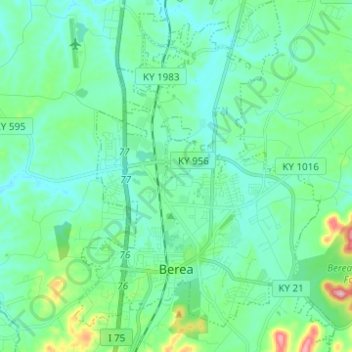
Nome: Mapa topográfico Berea, altitude, relevo.
Local: Berea, Madison County, Kentucky, United States (37.54556 -84.33198 37.64341 -84.23968)
Altitude média: 300 m
Altitude mínima: 261 m
Altitude máxima: 463 m
Berea is located on the border of the Cumberland Plateau. The area has a mountainous appearance, but most outcroppings in the area have a maximum elevation of 2,500 feet or 760 metres.
Outros mapas topográficos
Clique em um mapa para visualizar sua topografia, sua altitude e seu relevo.
Redhouse
United States > Kentucky > Madison County
Redhouse, Madison County, Kentucky, United States
Altitude média: 248 m
Newby
United States > Kentucky > Madison County
Newby, Madison County, Kentucky, United States
Altitude média: 272 m
Welch Mountain
United States > Kentucky > Madison County
Welch Mountain, Madison County, Kentucky, 40404, United States
Altitude média: 315 m
Fort Boonesborough State Park
United States > Kentucky > Madison County > Boonesborough
Fort Boonesborough State Park, Boonesborough, Madison County, Kentucky, United States
Altitude média: 236 m
Richmond
United States > Kentucky > Madison County
Richmond, Madison County, Kentucky, 40475, United States
Altitude média: 281 m
Berea
United States > Kentucky > Madison County > Berea > Berea
Berea, Madison County, Kentucky, 40404, United States
Altitude média: 314 m
Richmond
United States > Kentucky > Madison County > Richmond
Richmond, Madison County, Kentucky, 40475, United States
Altitude média: 267 m