
Mapa topográfico Haast
Mapa interativo
Clique no mapa para exibir a altitude.
Sobre este mapa
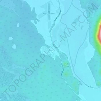
Nome: Mapa topográfico Haast, altitude, relevo.
Local: Haast, Westland District, West Coast, New Zealand (-43.90066 169.02203 -43.86066 169.06203)
Altitude média: 15 m
Altitude mínima: 2 m
Altitude máxima: 271 m
Outros mapas topográficos
Clique em um mapa para visualizar sua topografia, sua altitude e seu relevo.
De La Beche
New Zealand > West Coast > Westland District
De La Beche, Westland District, West Coast, New Zealand
Altitude média: 2.480 m
Junction Hill
New Zealand > West Coast > Westland District
Junction Hill, Westland District, West Coast, New Zealand
Altitude média: 784 m
Hidden Peak
New Zealand > West Coast > Westland District
Hidden Peak, Westland District, West Coast, New Zealand
Altitude média: 1.877 m
Fox Glacier
New Zealand > West Coast > Westland District
Fox Glacier, Westland District, West Coast, New Zealand
Altitude média: 1.836 m
Franz Josef Glacier
New Zealand > West Coast > Westland District
Franz Josef Glacier, Westland District, West Coast, New Zealand
Altitude média: 1.709 m
Amherst Glacier
New Zealand > West Coast > Westland District
Amherst Glacier, Westland District, West Coast, New Zealand
Altitude média: 1.819 m