
Mapa topográfico Fox Glacier
Mapa interativo
Clique no mapa para exibir a altitude.
Sobre este mapa
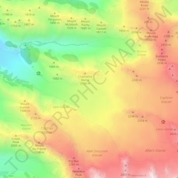
Nome: Mapa topográfico Fox Glacier, altitude, relevo.
Local: Fox Glacier, Westland District, West Coast, New Zealand (-43.53543 170.06385 -43.49793 170.16953)
Altitude média: 1.836 m
Altitude mínima: 718 m
Altitude máxima: 3.044 m
Chancellor Hut was built in 1930–31 on the southwest face of Chancellor Ridge, now 200 m above the glacier. Planned by mountain guides Alec and Peter Graham in 1929, all the materials had to be packed up Fox Glacier manually in 1930 in the days before helicopter airlifts. It is the oldest remaining mountain hut in the Southern Alps still on its original site, and is a Category II Historic Building on the Heritage New Zealand list. At an altitude of 1200 m, it was designed to provide climbing opportunities to tourists, rather than as a staging post for mountaineers climbing on the Great Divide. A hut was also built at 5,000 feet (1,500 m) on Craig's Peak (6,000 feet (1,800 m)) for overnight climbing trips.
Outros mapas topográficos
Clique em um mapa para visualizar sua topografia, sua altitude e seu relevo.
De La Beche
New Zealand > West Coast > Westland District
De La Beche, Westland District, West Coast, New Zealand
Altitude média: 2.480 m
Junction Hill
New Zealand > West Coast > Westland District
Junction Hill, Westland District, West Coast, New Zealand
Altitude média: 784 m
Hidden Peak
New Zealand > West Coast > Westland District
Hidden Peak, Westland District, West Coast, New Zealand
Altitude média: 1.877 m
Haast
New Zealand > West Coast > Westland District
Haast, Westland District, West Coast, New Zealand
Altitude média: 15 m
Franz Josef Glacier
New Zealand > West Coast > Westland District
Franz Josef Glacier, Westland District, West Coast, New Zealand
Altitude média: 1.709 m
Amherst Glacier
New Zealand > West Coast > Westland District
Amherst Glacier, Westland District, West Coast, New Zealand
Altitude média: 1.819 m