
Faça uma doação
Mapa topográfico Gosau
Clique no mapa para exibir a altitude.
Faça uma doação
Gosau
Gosau is situated along the Gosaubach stream in the Salzkammergut region. The center of the town is at an elevation of 767m (2,516'). 58.9% of the municipality is forested. At the southern end of Gosau there is a road leading to the Vorderer Gosausee, a lake with a view of the Dachstein.
Faça uma doação
Sobre este mapa
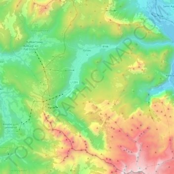
Nome: Mapa topográfico Gosau, altitude, relevo.
Local: Gosau, Bezirk Gmunden, Upper Austria, 4824, Austria (47.47303 13.47537 47.63038 13.65163)
Altitude média: 1.336 m
Altitude mínima: 502 m
Altitude máxima: 2.900 m
Faça uma doação
Outros mapas topográficos
Clique em um mapa para visualizar sua topografia, sua altitude e seu relevo.
Hoher Dachstein
Austria > Upper Austria > Bezirk Gmunden > Gosau
The Dachstein massif covers an area of around 600 square kilometres (230 sq mi) with dozens of peaks above 2,500 m, the highest of which are in the southern and southwestern areas. The main summit of the Hoher Dachstein is at an elevation of 2,997 metres (9,833 ft). Seen from the north, the Dachstein massif is…
Altitude média: 2.341 m
Faça uma doação
Predigstuhl
Austria > Upper Austria > Bezirk Gmunden > Bad Goisern am Hallstättersee
Altitude média: 921 m
Bad Goisern
Austria > Upper Austria > Bezirk Gmunden > Bad Goisern am Hallstättersee > Bad Goisern
Altitude média: 644 m
Faça uma doação
Faça uma doação