
Mapa topográfico Ankeny
Mapa interativo
Clique no mapa para exibir a altitude.
Sobre este mapa
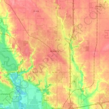
Nome: Mapa topográfico Ankeny, altitude, relevo.
Local: Ankeny, Polk County, Iowa, United States (41.65213 -93.67277 41.80218 -93.54144)
Altitude média: 284 m
Altitude mínima: 237 m
Altitude máxima: 314 m
Like most of Polk County, Iowa, Ankeny exists at the bottom area of the Des Moines Lobe, a topographical landscape area, in an area known as the Bemis Advance. The Lobe was formed during the Wisconsin glaciation leaving significant deposits resulting in an area with low relief.
Outros mapas topográficos
Clique em um mapa para visualizar sua topografia, sua altitude e seu relevo.
Des Moines
United States > Iowa > Polk County
Des Moines, Polk County, Iowa, United States
Altitude média: 264 m
West Des Moines
United States > Iowa > Polk County
West Des Moines, Polk County, Iowa, United States
Altitude média: 280 m
Pleasant Hill
United States > Iowa > Polk County
Pleasant Hill, Polk County, Iowa, 50327, United States
Altitude média: 259 m
Crocker
United States > Iowa > Polk County
Crocker, Polk County, Iowa, 50226, United States
Altitude média: 295 m
Clive
United States > Iowa > Polk County
Clive, Polk County, Iowa, 50325, United States
Altitude média: 287 m
Sheldahl
United States > Iowa > Polk County
Sheldahl, Polk County, Iowa, 50243, United States
Altitude média: 314 m
Saylorville
United States > Iowa > Polk County
Saylorville, Polk County, Iowa, 50313, United States
Altitude média: 266 m
Bondurant
United States > Iowa > Polk County
Bondurant, Polk County, Iowa, United States
Altitude média: 294 m
Scott Avenue Dam
United States > Iowa > Polk County > Des Moines
Scott Avenue Dam, Des Moines, Polk County, Iowa, 50319, United States
Altitude média: 247 m
Saylor
United States > Iowa > Polk County
Saylor, Polk County, Iowa, 50313, United States
Altitude média: 265 m
Urbandale
United States > Iowa > Polk County
Urbandale, Polk County, Iowa, United States
Altitude média: 279 m
Big Creek State Park
United States > Iowa > Polk County > Polk City
Big Creek State Park, Big Creek Drive, Polk City, Polk County, Iowa, 50226, United States
Altitude média: 286 m
Grimes
United States > Iowa > Polk County
Grimes, Polk County, Iowa, 50111, United States
Altitude média: 292 m
Polk City
United States > Iowa > Polk County
Polk City, Polk County, Iowa, 50226, United States
Altitude média: 284 m
Johnston
United States > Iowa > Polk County
Johnston, Polk County, Iowa, 50131, United States
Altitude média: 267 m
Des Moines
United States > Iowa > Polk County > Des Moines
Des Moines, Polk County, Iowa, 50319, United States
Altitude média: 271 m
Altoona
United States > Iowa > Polk County
Altoona, Polk County, Iowa, 50009, United States
Altitude média: 286 m
Jester Park
United States > Iowa > Polk County
Jester Park, Polk County, Iowa, United States
Altitude média: 273 m
Polk City
United States > Iowa > Polk County > Polk City > Polk City
Polk City, Polk County, Iowa, 50226, United States
Altitude média: 279 m
Ankeny
United States > Iowa > Polk County > Ankeny
Ankeny, Polk County, Iowa, 50023-3054, United States
Altitude média: 289 m
Johnston
United States > Iowa > Polk County > Johnston
Johnston, Polk County, Iowa, 50131, United States
Altitude média: 262 m