
Mapa topográfico Ankeny
Mapa interativo
Clique no mapa para exibir a altitude.
Ankeny
Like most of Polk County, Ankeny exists at the bottom area of the Des Moines Lobe, a topographical landscape area, in an area known as the Bemis Advance. The Lobe was formed during the Wisconsin glaciation leaving significant deposits resulting in an area with low relief.
Sobre este mapa
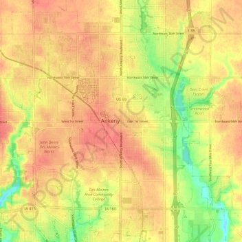
Nome: Mapa topográfico Ankeny, altitude, relevo.
Local: Ankeny, Polk County, Iowa, 50023-3054, United States (41.69187 -93.64038 41.77187 -93.56038)
Altitude média: 289 m
Altitude mínima: 255 m
Altitude máxima: 307 m